In the summer of 1804, following a directive from President Thomas Jefferson, the Lewis and Clark Expedition of Discovery departed from Camp Wood near St. Louis, Missouri and proceeded to paddle their way UP the Missouri River in search of a connection to the Columbia River and the Pacific Ocean. They journeyed up the Missouri River in the summer and fall to Fort Mandan, in what is now North Dakota, and camped there over the winter before resuming their push to the ocean the following spring.
With high water conditions greeting them in the spring of 1805, the expedition continued upstream on the Missouri River to Three Forks, Montana where the Madison, Jefferson and Gallatin Rivers converge to form the Missouri River. Because it was the west trending of the three forks the expedition chose the Jefferson River, so named by them, to the land of the Shoshone Nation where they befriended the native people who eventually led them over the Bitterroot Mountains on horses to where they began their final push toward the Pacific Ocean.
Once over the Bitterroots, the Lewis and Clark expedition carved dugout canoes from trees and proceeded down the Columbia to the mouth of the river on the Pacific Ocean before turning around and starting their journey back home. Along the way they created detailed maps and drew pictures of landscapes and wildlife, most of which had never before been seen by the eyes of white men. They opened up the west to discovery, and also opened the door to the destruction of native peoples and their cultures as the west became part of the United States. They completed the initial trip in September, 1806, when they arrived back at St. Louis to report their findings to President Jefferson.
My trip began early (5:00 AM) on September 9, from Emmett, Idaho and took me north on US 95 to Kooskia, Idaho, driving through Council to Riggins, Whitebird and then to Kooskia where I intersected US 12 east toward Lolo Pass on the Idaho-Montana state line. Along the way I drove by the Weiser, East Fork of the Weiser, Little Salmon and Main Salmon Rivers. Heading east on US 12, I drove by the Clearwater and South Fork of the Clearwater, Lochsa and Selway Rivers in Idaho through the Payette and Clearwater National Forests on one of the prettiest drives one can take in America. The only downside was the dense smoke and smell of burning forest fires in Idaho, Montana, Oregon, California and British Columbia (Canada), but my air conditioner overcame most of the odor. My drive from home to Fort Benton was a little over 600 miles through Lolo, Missoula and Great Falls to Fort Benton, and it was a most enjoyable drive with very little traffic and LOT of wonderful scenery all around me.
Reports told me that wildfires would cause delays and possibly road closings all along my planned route, but a longer route would have added well over 100 miles each way and would have been almost all Interstate highways with a lot less scenery and a lot more traffic. As it happened, I had no traffic delays and only saw one burn location of a few acres that had burned a couple hundred yards off the highway several days earlier. It was a great choice to travel the scenic route!
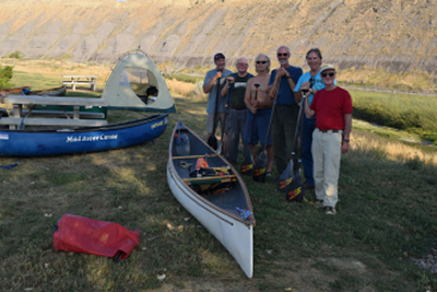
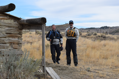
On the afternoon of September 9, 2017, a group of six led by intrepid explorers Larry Rice (now of Colorado) and Cliff Jacobson (Wisconsin) met in Fort Benton, Montana to canoe the Big Muddy (Missouri) River going downstream from Fort Benton to James Kipp Recreation Area. The group included Darrell Foss (Minnesota), Jeff Josephs (Wisconsin), Bob Tucker (Missouri) and Marc McCord (myself), a Texan now living in Idaho. Our Journey of Discovery would be a GPS distance of 153.67 miles over ten days, two of which would be layover days allowing us to rest, explore and photograph the surrounding area.
On September 10, we drove to Chouteau County Fairgrounds in Fort Benton where we unloaded all our gear, set up camp, and then, leaving Darrel behind to guard it all, shuttled our vehicles downriver to James Kipp RA, where we parked, then rode back to Fort Benton with our shuttle driver, Bert, from Missouri River Outfitters. The round trip took about 6 hours for the 145 mile drive each way, and shuttling before the trip allowed us to load our five personal vehicles and then depart our separate ways at the end of the trip rather than loading a shuttle vehicle, driving back to Fort Benton, unloading the shuttle vehicle, loading our personal vehicles and then driving home from Fort Benton. Other than the additional loading and unloading of the shuttle vehicle it would not have made any real difference to me because Fort Benton was along my route back home, but the other guys saved probably 7-8 hours, at least, by being able to depart directly from the take-out.
We camped overnight on September 11, at Chouteau County Fairgrounds at the canoe launch campsite adjacent to the river, and then departed in mid-morning, with paddles wet at 8:55 AM on September 12. Our first day destination was some 19.1 miles downriver at a designated campsite called Black Bluff Rapids Primitive Boat Camp. The river was flowing at about 4,280 cfs, down from over 6,000 cfs just a week earlier, and we made excellent progress, covering the distance in 4 hours 9 minutes of paddling time at an average moving speed of about 4.6 mph and an overall speed (including stops of 38 minutes for lunch and breaks) of about 4.0 mph.
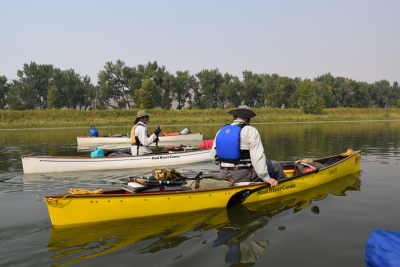
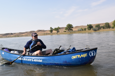
We traveled in a variety of solo expedition canoes - Larry Rice in a Mad River Traveler, Cliff Jacobson in a Northstar (Bell) Phoenix, Bob Tucker in a Mad River Outrage (whitewater canoe), Darrell Foss in a Wenonah Slipper, Jeff Josephs in a Wenonah Encounter and myself in an Old Town Appalachian outfitted as a solo canoe with a tractor seat and plenty of D-rings for lashing gear. Bob struggled from the outset due to the short length, outfitting and rocker of his boat, but we just took a little extra time so he could stretch his legs every couple of hours and we made it to each day�s destination with plenty of daylight in which to set up camp.
The first day was very smoky from the forest fires burning just a few miles away, and the sky was choked with a grey hue, but we had light wind and a good current that facilitated our progress. On the first night we hit the bottle - of Dr. Bronner�s Pure Castile Peppermint Soap - to soak our faces and breathe in the pore and sinus opening vapors from hot towels placed over our faces. Those of us who have been using this stuff for years relished the experience immediately. Those experiencing it for the first time, which was only Bob, were amazed and duly impressed, and it was a frequent feature on several nights during the trip, which made us all smell a little better. (I frequently use it to give myself a full body bath on extended trips when showers are not available and river water leaves me feeling almost as dirty as I was before immersion.)
Being that I was with a bunch of old guys, everybody else was in bed by 8:45 PM - they stayed up "late!" - and I was in my tent at 9:30 PM, when the wind began to blow. It blew hard most of the night, but by morning it had blown away much of the smoke and odor from the forest fires to our west, north and east.
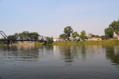
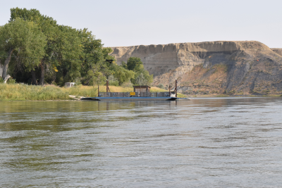
Day Two was our longest day on the water at 28.4 miles down to Little Sandy. I was the last boat on the water at 8:58 AM and we were off the river by 5:00 PM at a moving average of 3.94 mph on a current of 4,570 cfs with moderate morning headwinds turning very strong in the afternoon. We saw a couple of jet boats that were courteous and caused us no problems, but we saw no other canoeists. I photographed a cable ferry just below Coal Banks River Access, one of several active ferries operating along the river, though this one was inactive at the time.
That night, the wind continued until dark and then the rains began to fall as the temperature began to drop around 8:00 PM. I was glad I brought my zero bag! Everybody retired to tents early, especially after a day of 7 hours 13 minutes paddling time against formidable headwinds. We had a short day the next day (Thursday) and then a layover on Friday, which turned out to be great planning because it rained off and on all day Thursday and remained very cool, making me glad I had packed winter clothing for a trip that was supposed to have daytime highs in the 90�s and overnight lows in the upper 50�s.
I finished off Day Two with a couple of Ibuprophen PM chased with an ice cold Coke Cherry Zero and then crawled into my sleeping bag to rest my weary bones. It was a VERY long day paddling 28.4 miles against that wind! Day Three (Thursday) was only going to be about 9.8 miles before taking a layover, so we lounged around, ate a late breakfast and tried to wait for the rain to abate before striking camp. Alas, we packed away wet tents and hit the river at just about 12 noon and were off the river by 2:23 PM on a moving average of 4.39 mph. We actually had a slight to moderately strong tailwind, though it was no help and actually caused some steering control problems by catching my big drybag that I had rigged behind my seat for a back rest. It rained all day.
Just as we were launching we were passed by a very large (close to 30 people) college group that put in at Coal Banks for a 3-day trip down to Judith Landing. They traveled in tandem canoes with raft support, and they were NOT outfitted for the wind and rain. In fact, some of them looked downright miserable on their first day. It took me about 45 minutes to catch and overtake the lead boat in the college group that had passed me 15 minutes before I launched. By paddling steadily we managed to reach our preferred campsite at Eagle Creek just ahead of their motor-assisted raft, which was trying to get there first. Due to its heavy load and our desire to have first choice of campsites we paddled hard enough to accomplish our mission, and were already unloading when the raft arrived. The college group camped just downriver from us at an adjacent site about 500 feet below our site. We never heard a peep out of them that night!
Another group of four people in two tandem canoes came in late in the day and camped between us and the college group. Like the college group, they were heading for a take-out at Judith Landing and we would not see them again after we departed Eagle Creek because we had a layover day on Friday.
Our campsite, like most of those on this trip, had a vault toilet, a fire ring and plenty of firewood, but fires were prohibited due to the extremely dry wildfire conditions, so all we could do was wear warm clothing and wish we could have a campfire. Our meals were all cooked over gas stoves, so that was not really a major imposition. Still, the atmosphere of a campfire is an integral part of most of our trips. The two things we did miss were sunshine and warm temperatures. Friday night was forecast to be the coldest of our trip, and as dark approached we could tell it would probably be just that (and it was!) The upside was that we smelled no smoke from forest fires.
On Friday, September 15, we lazed around all day. It was still raining steadily at 7:30 AM and the temperature was in the 30�s, which made staying in bed a little longer easy to do. By late morning the rain was light enough, stopping briefly, that we took a short hike to look at some side canyon topography, but then the rains continued until about 4:30 PM, but by about 6:30 PM it was raining again and getting colder. By 8:30 PM it was raining harder and we retired to our tents to start packing everything we could for our departure on Saturday morning. We were just over one third of the way through our trip with 5 paddling days and one layover day still to go.
Our fourth paddling day started wet and cold with light rain as we broke camp and loaded our canoes. We got on the river around 11:00 AM and paddled 21 miles in 4 hours 52 minutes of paddling time with an hour of stop time for lunch and breaks. It was the closest to uncomfortable I had been on the trip due to to somewhat chilled fingers and feet. Expecting hot weather, I left my NRS Neoprene-lined Workboots in my van and wore my Merrill watershoes with Capilene socks, but those were not enough to keep my wet feet warm and comfortable. Still, by concentrating on paddling I was able to stay mobile and moving at an average of 4.32 mph.
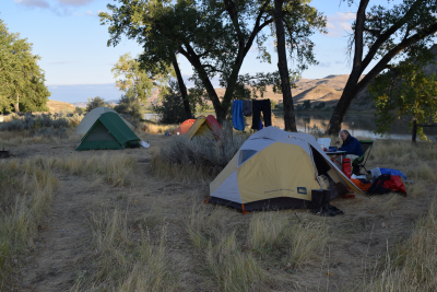
The sun tried to shine, but did not quite make it while we were on the river, though it managed to break out after we reached our campsite at Slaughter Creek. It warmed us a little, but more importantly it dried our tents, which we were forced to pack away wet when we broke camp today. The campsite had two vault toilets and a couple of 3-sided, covered shelters, one of which we used to set up our kitchen. It was dry and out of the wind. We shared our campsite with 2 couples from Falls Church, Virginia who worked for a lobbying company in Washington, DC, and who brought us a load of firewood, though we could not use it due to the open fire prohibition still in effect.
After about 54 hours of nearly continuous rain it was great to have mostly clear, dry skies above us. We were now some 78.3 miles downriver - approximately half way through our trip, and right on schedule. We were in our tents by about 9:00 PM, though not in bed, expecting a long day of about 25 miles tomorrow.
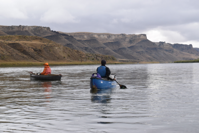
Sunday, September 17, was our fifth paddling day and our sixth consecutive day on the river. It was a warm, sunny day with perfect paddling conditions. We were well within the White Cliffs section of the Missouri Breaks and were beginning to see wildlife along the river. We launched at 10:48 AM and then paddled about 27.22 miles in 6 hours 55 minutes of paddling time with an additional 47 minutes of break time, taking out at McGarry Bar campsite at about 6:30 PM on a moving average of about 3.94 mph and an overall average of about 3.54 mph on a flow rate of about 5,630 cfs - we got a small bump from the rains that fell, though the change in current was nearly imperceptible.
Throughout the day we saw a coyote, many cows, a few horses and a LOT of geese and ducks. It was the first truly great day for photographs, and I took many. It was also some of the most amazing scenery of our entire trip along our route. Bob was starting to feel the burn of paddling on his knees in his whitewater canoe for all those miles, so I dropped back and paddled with him a little behind the rest of the group. At the end of the day we were 105.52 miles into our trip - just over two thirds of our total distance with one more layover day (tomorrow) and then three more paddling days to the end of the trip. We were in great shape and only needed to average less than 15 miles per day over the last three days. Today�s high temperature was in the mid-70�s, and it felt great!
I exceeded a personal mark of over 1,200 miles paddled this year today - I had hoped to reach 1,100 miles by the end of September, and I shattered that goal. By 8:30 PM it was down to 48 degrees and dropping toward a very cool night. The zero bag felt great!
Monday, September 18, was our second and last layover day. It warmed slowly from overnight lows in the lower 40�s and the sun did not break out until after 2:00 PM, but it was a gorgeous day after that. We did a short hike up a side canyon and then returned to camp to shoot targets with our pellet pistols. We pulverized some soft drink and beer cans from a distance of about 15 yards, and we felt that we were ready in case of a bear attack, though (luckily for the bears) we never saw any.
By 6:00 PM the sky was darkening and by 8:30 PM it was raining again, though much more lightly than earlier in the trip. We retired to our tents and began packing for departure the next day, as well as doing some reading and logging in our journals, which is how we closed almost every day.
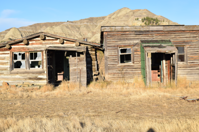
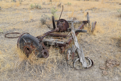
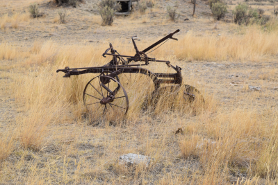
On Tuesday, September 19, we arose early with Larry�s usual 6:30 AM wake-up shout out and began to prepare for a long day on the river so that we would have two shorter days to close out the trip. We were now at mile 125.8 in less than 31 hours of paddling time since Fort Benton at an overall average speed of 4.6 mph. We were greeted by cool, dry, windy conditions with a strong tailwind from the west-northwest and frequent wind gusts that would make steering difficult. We launched at about 10:00 AM, and I remained back with Bob, the two of us not in as much a hurry as the other guys seemed to be. We had all day, and we were all going to the same place, so Bob and I kicked back and enjoyed the scenery. We stopped and photographed a couple of old homesteads and their remains, saw camps used by Lewis and Clark, and I took a lot of photos of the river and surrounding topography.
Around 2:00 PM a warm sun appeared and took the chill off the day. We ran some "rapids" today, though I am not sure why they are called rapids, or why anybody in the past had any problems at them unless they were substantially more difficult long ago than today. Even after more than 54 hours of continual, slow, soaking rain the grasses along the banks were tinder dry and flammable. Cliff was champing at the bit to build a campfire, but the ban was still in place (as far as we knew) and we convinced him not to burn down Montana.
We were all off the river at Gist Bottom by 4:45 pm with a moving time of about 5 hours 15 minutes at a moving average of 3.86 mph, slowed in part due to just floating for extended periods as the wind blew us downriver. These party animals prepared dinner early and were in bed by 8:30 PM, so they could get up at 6:30 AM, which is not always bad considering that the wind usually starts blowing in early afternoon. Tomorrow morning we are sleeping in with our wake-up call coming at 7:30 AM. Woohoo!
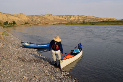
Wednesday, September 20 - our next to last day of the trip - saw us on the water by 11:00 AM for a run of about 15.1 miles at a moving average of about 3.86 mph, and by the end of the day we were at 140.9 miles below Fort Benton. We rode a current of about 5,060 cfs with a strong tailwind which, once again, played havoc with boat control. The day started with warm, bright sunshine that turned to an overcast sky not long after we launched. I was hoping for warmth and no wind all day - I did not get my wish! But, as with every day on this trip, the scenery made up for the less than preferable weather conditions, and it could have been so much worse, so we really were not complaining. We were, after all, on the Lewis and Clark Trail paddling an historic river through some remarkably gorgeous hills and high desert.
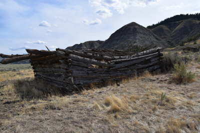
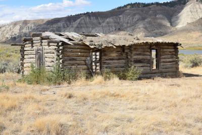
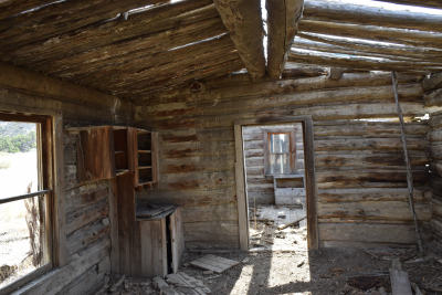
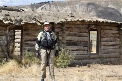
I ended up wearing what I wore most days - my wetsuit and drytop over a base layer for warmth. We stopped at the Cow Island Preserve historical site and took many photos of rustic relics of times long past. There were about 8 remains of various buildings and equipment where a river ford existed in the 1800�s, and where the Battle of Cow Island was fought between the Nez Perce Nation and Anglo settlers moving west in the Nez Perce War of 1877. One can feel the type of life that must have been lived on these plains in the Missouri Breaks and you gaze over the ruins and the typography of the area that sits between Cow Creek and Bull Creek. Larry, Bob and I wandered around this site while Darrell, Cliff and Jeff paddled on toward our campsite for the night at Hideaway Primitive Boat Camp.
Wind continued into the night, though it got lighter than earlier in the day. By 9:30 PM, I did not hear a peep out of anybody! They were all out like a light. did some reading about Idaho rivers I want to paddle and logged trip details in my journal before crawling into bed around 11:00 PM, which is actually very early for me - at home, I am usually in bed sometime between 2:00 and 3:00 AM.
We arose early on Thursday, September 21, and proceeded to break camp right after breakfast. We were on the river by 9:34 AM, and Bob and I pulled into James Kipp Recreation Area at our take-out at 12:00 Noon. We rode a current of about 4,870 cfs at an average speed of 5.25 mph. We had a cool, dry day with light wind, and we flew downriver. Larry, Jeff, Cliff and Darrell were partially loaded up by the time Bob and I arrived, but we took our time carefully packing our vehicles for the drives back home.
We were on the road by 1:30 PM after changing into warm, dry clothes and exchanging farewells. Everybody had a great time on the trip and we are looking forward to our next big adventure, probably in late-March or early-April of next year. Personally, I want to do this run again taking a couple of extra days to really explore more, and possibly adding a third layover day to facilitate that exploration. This was an easy paddle on all flatwater that anybody could do. It is well suited to canoes or expedition kayaks, but Bob probably would not recommend a whitewater canoe and I doubt rafts would be much fun unless you were really interested in a slow trip.
I shot 472 photos during the trip, though I missed 3 days of photographing due to the rain. I created a slideshow on Southwest Paddler ( Upper Missouri River 2017) using a sampling of the many photos I took during our trip. The youngest guy in our group was 68 years old and Cliff turned 77 on the next to last day. Our total trip distance was 153.67 miles in less than 37 hours of paddling time - not bad for a group of old farts! I was one fantastic trip. See you guys next year!

