The last time I ran the Lower Pecos River in Val Verde County, Texas was in April, 2007. Since that time the river has never been at a navigable level long enough for me to put together a group and drive the 8 hours it takes to get there from Dallas. The Pecos River is a principle tributary of the Rio Grande having its confluence on Lake Amistad just west of Comstock and Del Rio, and it is a very special place to canoe when it has water, but it sits in the Chihuahuan Desert Southwest in an area where rattlesnakes easily outnumber people, though I have never seen one there. What you do see is a lot of sand, rock, cactus and desert scrub everywhere you look for a couple hundred miles in any direction (many more if you are looking west or south.) But, just every now and then we get lucky and 2014 was such a year.
In late September, the skies opened up and dumped 10-12 inches of rain throughout the Upper Pecos watershed in Northern New Mexico and the Texas Panhandle. We started watching the water descend the river channel starting at Red Bluff Reservoir on the Texas-New Mexico state line, and then planned our departure to coincide with a rising river at Pandale Crossing nearly 200 miles downstream. With great anticipation we watched as the water worked its way down through Pecos, Girvin, Sheffield, and then toward Pandale. In a matter of a couple of days I got confirmations from my friends Tom Taylor, Stan Pully, Gary Tupa (who ran the river with me in 2007), Jason Gonzales and Mitch McKinzey for participation in this trip. Only Gary and I had ever run any part of the Pecos and the others were anxious to experience this fantastic river that our very envious friends Larry Rice and Jason Jones wanted to do, but were kept away by prior commitments. When the Pecos flows you just have to be able to drop everything else and go because it will not wait for you. But, the six of us were a great group who worked together every step of the way and enjoyed a trip of a lifetime that few paddlers will ever experience.
Typically, the Pecos gets some local rainfall and then runs out quickly due to a moderate 6.6 feet per mile gradient flowing over a limestone bottom. This year, we got especially lucky in that it rained locally and upriver more than a week before our departure, with the local area getting about 5 inches of rain resulting in the desert blooming into a vast array of colors - reds, blues, greens, yellows, purples and oranges in addition to the usual shades of brown. Flowering plants that are seldom seen were on full display on the drive down to the river and all along our path as we paddled. The problem was that we mistimed the water moving downstream and actually got there about a week earlier than would have been ideal, but it was, nonetheless, an excellent level that made the trip interesting and exciting, especially for those who had never before seen it in person.
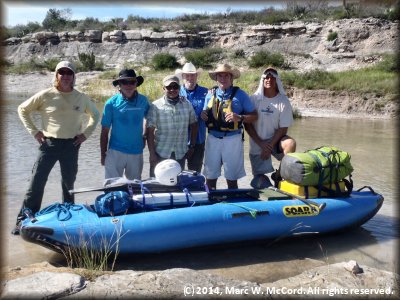
I contacted my friends Emilio and Lupe Hinajosa in Comstock to arrange our shuttle and they graciously allowed us to camp overnight in their yard the night before our trip, saving us some time and money, as well as making it very convenient for us to get an early start on the morning of October 6, our launch date. We had just about perfect weather - cool at night and warm under mostly sunny skies during the days. We drove from Comstock to Pandale Crossing, unloaded gear and supplies, aired up our SOAR inflatable canoes, took a few photos and then got on the water where we discovered that it was a little shallow for the first mile or so below the put-in, but it caused only minor inconvenience as we walked our boats a few feet to find deeper channels. Gary and Tom had their SOAR S16's, Mitch was in my SOAR S16, Stan and Jason were in their SOAR S14's and I was in my SOAR S12 (which is BARELY big enough for my expedition packing load, but I scaled down for this trip and made it in relative comfort), though I would have preferred to be in the S16 with four more feet of room to load my gear lower in the boat and still have leg room in front of me. Luckily, Stan, Gary, Jason and Mitch helped carry community gear and supplies giving me a little more room in my boat. Tom carries a bigger load than I do, so he had no extra room for anything.
We planned the trip as a 4-day event based upon anticipated water levels and speed of the current. But, we took food for 6 days because you never know when the southeast winds are going to start blowing off Lake Amistad adding a day or two to your trip duration. The first two days were nearly ideal in every way, with light winds, occasionally cloudy skies, slightly cooler temperatures and plenty of new reed jungles in midstream to make the trip even more interesting that it normally would be. The severe drought of the past few years has allowed vegetation in the river channel to grow profusely, and it was obvious to me that I was on a "new" river even though it was my fourth trip down the Lower Pecos. It was Mitch's first real wilderness whitewater expedition and he was enjoying every minute of it, as were the rest of us who have done many such trips together on rivers all over the country over many years of paddling together. But, the Pecos gives you a true feeling of solitude and remoteness as you paddle through an area that is devoid of any signs of civilization other than a rare sighting of a residential structure, most of which are only occupied as vacation getaways, and this trip was no different - we saw a total of two other people, and they were fishing on the banks of the river on Day 5 near our take-out.
 Monday, October 6, our first day of paddling, began at about 11:30 AM. We paddled about 14.9 miles and were in a riverside camp on a rock ledge by about 4:30 PM. Along the way we encountered numerous Class I to II rapids that were fun, but not challenging, especially in our SOARs. We maintained a moving average of about 3.4 mph and had plenty of time for a lengthy lunch break during which time we swam in the river to cool off a bit and took many photos of the river and surrounding desert. The gentle breezes we encoutered during the day helped keep us cool and comfortable while not impeding our progress downriver. Most of the Lower Pecos is a canyon with 100-300 foot high walls on one or both sides, and we entered the canyon around 1:30 PM, where the vistas became even more enchanting and magical. The canyon is rich in ancient history depicted by 5-6,000 year old rock art in the form of petroglyphs, the most recent of which are estimated to be at least 1,400 years old. These are indications of civilizations that existed in the Lower Pecos area during the late- and middle-Archaic periods (6,000 - 2,500 B.C. and 2,500 - 1,000 BC, respectively.) There are also caves housing wall art that is unique, and the Continental Ranch at Lewis Canyon (which we enountered at the end of Day 3) is the site of the single largest petroglyph site in all of Texas, a treasure of several hundred rock art creations on a flat rock slab high above the river that was used as a ceremonial site by the First Nations inhabitants long ago. But, I digress.
Upon reaching our campsite we set up tents, our kitchen, took swims, and then prepared a dinner of Johnsonville brats with safron yellow rice and carrots. After dinner, we sat by the river's edge listening to the sound of rapids and gazing at stars - and an occasional satellite orbiting overhead, probably taking photos of us so that our government would know that we were "safe from harm", or something like that. Most of the group was asleep by 10:00 PM, but Mitch and I stayed up talking and enjoying a gorgeous Texas fall night under a nearly full moon lighting up the canyon walls and the river.
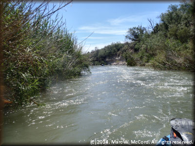 Tuesday began a lot easier than the first day, so we took our time getting started and ended up getting on the river only about 45 minutes earlier, but the river had risen slightly overnight and we had a good current, so we made up for "lost time." It is always fun running rapids that are hidden by dense reed jungles, and just like the nearby Devils River there are many of them (more, in fact) on the Lower Pecos. They keep you alert and on your game whle teaching you to paddle with your ears as much as with your eyes and blade. This is an important skill to have on a wilderness whitewater expedition where professional medical help is many miles and hours away - if you can contact somebody. Cell phones are useless here, so satellite phones are recommended for emergency assistance. At least we had a good water level and current to assist us in getting downriver. Although it was October, our second day on the water brought with it mid-90's temperatures, but as they like to say in Arizona, "it was a dry heat", whatever that means. By any measure it was still plenty warm and the river was nice and cool. We availed ourselves of its refreshing wetness on numerous occasions.
Along the way we encountered more beautiful weather with warm, partly sunny skies, a light breeze, increasingly challenging rapids, a lot more reed jungles in the middle of the river, deeper canyon walls and a whole lot of fun just being on the Pecos. It was so good to be back here after seven long years, and this time we had plenty of water. One characteristic that I noticed was that the river was much clearer than usual after a rain, probably because the local rainfall water was already downstream and what was coming down now was a release from Red Bluff Reservoir, which went from about 20-25% of conservation level to over 105% in a couple of days prompting releases from the bottom of the pool where the silt has already settled out and the water is cleaner. We could see bass, gar, crappie and other fish clearly, but we had not come to fish though a couple of the guys brought rods and reels just in case the opportunities presented themselves. We had set a goal of finishing in four days, and though Texas Parks and Wildlife claimed this run was about 55 miles I already knew it was going to be at least 62 because I had tracked it on Google Earth (it turned out to be 66.3 miles from Pandale to the Seminole Canyon boat ramp.) The headwinds on the Pecos always have a potential for extending a trip by one or two days, possibly more. But the first two days gave us great progress and we paddled about 16 miles on Day 2, ending up at Harkell Canyon on river right, so we were right on schedule when we camped that night. Besides, Stan assured us that we were sheltered from the wind (Stan was wrong!)
 After setting up camp along a creek flowing out of the side canyon we cooked a dinner of steaks, baked potatoes and BBQ beans that perfectly complemented being on the Pecos. Then, we settled in for a breezy evening under another starry sky with a full moon illuminating the canyon walls around us. It was truly a blissful night to camp along the river, and we enjoyed a restful sleep that came especially easy for half our group who were worn out from paddling 30.9 miles in two days.
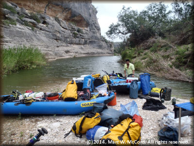
On Wednesday morning of our third day on the river we headed out for Lewis Canyon where we planned to take time to explore the ancient rock art at Continental Ranch and camp on the rock ledge that night. It would put us a few miles short of our planned 15-16 miles per day, but we figured we could make it up as the river continued to rise. We knew that we were in for a tougher day because the wind was blowing a little harder. But, the day was another gorgeous day in Val Verde County and so we got on the water a little earlier and began our push for the left bank campsite we planned to use - the same place Gary and I camped in 2007. The river was whitecapping on us as we fought against headwinds of probably 25-30 mph with a little stronger gusts that sent us spinning and pirouetting down the river. Thankfully, we still had a decent current to assist our forward progress - and we needed it!
We found more reed jungles, increasingly difficult (though still very manageable) rapids and as much gorgeous, natural scenery as we could hope to find. Most of us spent a lot of time taking photos of this magical river valley and we all cherished having it all to ourselves. So far, we had not seen another soul, and that would continue until our last day. When we finally called it a day we had gone only 11.5 miles of our intended 15 miles, but it was time to get off the river and we were spent from fighting the wind, sun and surf. Besides, we were exactly where we wanted to be, and that was all that really mattered, especially since we were prepared for up to six days on the river.
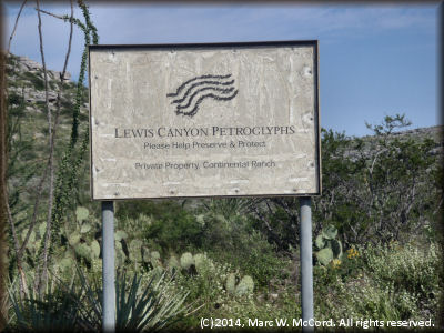 Upon reaching Lewis Canyon in late afternoon we took time to set up chairs, drink a cool, soft beverage, and then make the climb up the steep jeep trail to the petroglyph site. Everybody in the group was impressed by the ancient works of rock art we saw and photographed. We probably spent at least an hour on the site walking the vast, flat rock slab and viewing literally hundreds of pieces of art scattered over what must have been at least an acre, probably more, a couple hundred feet above the river and our campsite for the night. The photographs in the slideshow will suffice for commentary on what we observed. If you happen upon this site, then please be respectful of Continental Ranch's private property and be especially respectful and protective of the ancient antiquities that make this place so special because it is irreplacable. So many such sites have been defaced by vandals and classless people who think it is important to leave their own mark behind.
We also found signs of recent "civilizations" leaving their mark on the river just below Lewis Canyon. Out of the river, but on the left bank up against the cliffs, were three almost new and completely trashed white King Cab 4X4 Dualie pickups that had been carried downstream from some unknown place by a June flood and buried in mud that had since washed away enough to expose the exteriors, though the interiors were still well packed. In the river we found another red pickup that was literally ripped apart with jagged metal edges sticking out everywhere and pointing upriver just waiting to grab some unsuspecting boater. Fortunately, it is easily avoidable, but all four need to be removed due to their potential for environmental damage and the potential for human injury by the red one. These were about the last things we expected to see, and if they are not removed, then I would bet that people 5-6,000 years from now may be gazing at the petroglyphs in wonderment, but somehow I doubt the trucks will still be there, having rusted into oblivion long before.
That evening we dined on grilled chicken leg quarters, yellow rice and green beans. I forgot to mention that I had brought two bags of chocolate and two bags of mint Oreos, and Tom had brought one bag each of double stuffed original, chocolate and mint Oreos, so each night we had Oreos and milk for dessert, and they were the perfect finale to our great meals. After dinner we settled in for another night of stargazing, resolving the world's problems and discussions about what a magnificent place it is that we were experiencing together. Everybody agreed that we have to come back again, and I just hope the wateres allow us that opportunity in less than another seven years because that's just too long to wait.
Tent stakes are a waste of space and add extra weight along the banks of the Pecos, so we had to set up tents and then weigh them down with our gear bags and rocks we found near our campsites. Wednesday night was the second night of strong winds, but at least they were tolerable, and they kept us cooler, which is always nice on the Pecos. But, we were now just a little behind schedule and we expected more wind the following day, so we got a good night's rest and then arose earlier than usual to get started while the winds were a little calmer - they tend to pick up in late morning to early afternoon.
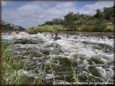 Thursday began much like Wednesday. The wind was our real obstacle, and it slowed us perceptibly - we only made about 10.5 miles that day and would need another full day of paddling to reach our destination. Departing from Lewis Canyon the real fun begins because this marks the spot where the rapids get much more technical and challenging. The first up is Lewis Canyon Rapid, a solid Class II to II+ that is fairly easy to read and run, but since only Gary and I had been here before we scouted for the benefit of our fellow travelers. Everybody ran the rapid without incident and continued on downriver a little wetter and a little cooler than before the run. Shortly after that comes the second most challenging rapid on the river - Shackleford Rapid - a solid Class III to III+, boulder filled, turn and burn run that begins with a right to left to right entry into a gradient drop of several feet among huge boulders before coming to a ledge drop of a few feet into a run-out of boulders and holes that screams like a banshee for about one tenth mile. If you set up properly, then this run is actually easier than it looks, but it is one that requires precise boat control and quick maneuvering to prevent swimming in a place where you definitely want to stay inside your boat and keep it upright. Happily, we all ran Shackleford with little difficulty, and we have photos and videos to prove it!
Again, we carefully scouted the rapid and set up both downriver safeties and cameramen to capture the excitement of the run. We did not have to rescue anybody and several of us got great photos and videos of runs though this fast, wet and exciting rapid. As each member of our group ran we shifted positions so that only one person at a time was at the top and everybody else was downriver in either a safety or camera position, though we were actually all acting as both. Shackleford Rapid is really more fun in a hard boat because the SOARs just eat these kinds of rapids for lunch, but they are still a blast - and a very wet ride, too! That water sure feels good on a warm day. The only bad part about the rapid would be the extreme difficulty of carrying boats back to the top for a second run, especially when loaded for a multi-day expedition. In 2007, this rapid seriously injured a canoeist just a couple of days before we were there and his group had to be airlifted out so they could get him to a hospital for treatment of a broken arm and shoulder that resulted from flipping his boat and being carried into boulders. The technical nature of this rapid makes respecting it and running it properly a top priority.
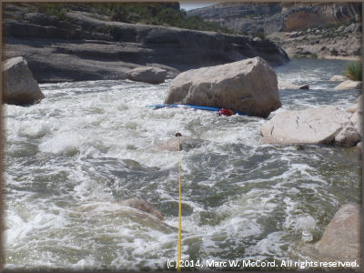 In mid-afternoon we reached Painted Canyon and its rapid was mean and nasty. We set up a downriver safety, then sent one boat down the gauntlet of boulders and cross currents. It got plastered on a huge boulder and required several ropes, all our energy and about 2.5 hours to recover it. We ended up losing our grill pan and rack, one of our two propane stoves, a couple bottle of propane fuel, a chair and ended up with wet charcoal, though it was sealed inside a bucket with a screw-on lid (we did not discover the wet charcoal until we got ready to cook that night.) After that, we decided to line the other boats because it was getting late in the day and we were now a little further behind schedule. In less than one hour we lined the other boats except for Stan's - he decided to run the rapid and nailed it perfectly down the middle. I was happy to see him run cleanly because had he pinned we would have been camping at Painted Canyon that night and we would be facing a six day trip.
We found a narrow slit of rock slab barely above the waterline on river left a couple miles below Painted Canyon and decided that was going to be our camp for the night. We were hoping the river did not rise quickly during the night, but we had almost everything in our boats in the event we had to make a hasty departure. The wind was still blowing and setting up tents was a "lot of fun!" Then, when we were set to cook our grilled pork steaks with scalloped potatoes and navy beans we discovered that our charcoal was sitting in a small amount of water that was just enough to assure lighting it would be impossible. Time for Plan B - I whipped out our backup food and prepared a nice dinner of beef stew and chicken and dumplings that took only ten minutes to prepare and was really great after all the energy we expended recovering the pinned boat. We hit the sheets early Wednesday night and slept peacefully until we awakened Thursday morning and began preparing for another windy day on the Pecos.
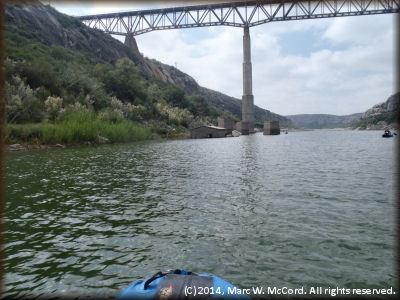
Friday, our fifth and last day on the river, was another windy monster that worked us to the bone. We started the trip with a 3.4 mph moving average after the first day, but by Friday we were down to a total average of only 2.8 mph and working much harder each day. We came to the weir spanning the river where I got caught in the hydraulic on river right seven years ago from which I had to abandon my boat, swim out and then wait nearly 30 minutes for it to release my boat so I could continue downriver. This time, we went far left, but the water was too low over the weir to run it, so we had to portage. In hard boats we may have been able to run it, but the Neoprene bottoms on our SOARs stuck like glue and made us have to work extra hard getting loaded boats down the backside. That was the ONLY negative to our SOARs on this entire trip - they otherwise performed admirably and perfectly. The scenery remained Class A, but our appreciation for it probably faded a little as we fought to make progress. Below the weir the river begins to widen substantially and you start to feel the mixed emotions of not wanting the trip to end, yet being glad that you will soon be out of the wind. The nearer you get to the take-out the more the lake effect becomes a factor and you lose the current, so we did not have any help against the headwinds. Still, we trudged on until we had paddled about 13.4 miles to the boat ramp below US Highway 90 where our trip ended. Before getting to the US 90 high bridge that signals the approaching boat ramp you see the very tall railroad bridge some 320 feet above the river, and at that point you know you are just over 3 miles from finishing the trip. It also signals that you have an hour or more of paddling against the wind before you get any relief! I am just thankful that we did not encocunter the 45-50 mph winds that have plagued me on a couple of previous trips. The last time we were there Emilio had a friend who met us at Dead Man Canyon and towed us behind his pontoon boat for a fee of $5 per person (we gladly gave him $10 each because we were so happy not to have to paddle those last few miles) but he no longer runs that taxi service and the guy who does it now charges $300, so we just bit the bullet and struggled against the wind.
 As we approached the US 90 bridge Emilio and Lupe were watching from on high. Having expected us the previous day they took our vehicles to the boat ramp, but when we didn't show up they returned them to their house, and then came back on Friday to watch for us. Now, THAT is what I call 5-star service! We started by 9:30 AM and ended around 4:30 PM, dead tired and ready for showers and a restaurant meal before heading home. In the end we decided to dump our trailer at Emilio's and Lupe's house, drive into Del Rio to get a motel room, shower, eat and then sleep in a regular bed under air conditioning before heading home on Saturday. It turned out to be a good plan, and it definitely made the drive home a lot more tolerable for Tom and me. Stan stayed with us then headed on to Kickapoo State Park for a few days. Gary, Jason and Mitch headed the three hours back to San Antonio after dinner Friday night, so they were home almost a day ahead of Tom and me.
When Tom and I returned to Emilio's house on Saturday morning to pick up the trailer there was a group of six guys from Houston who were on their way to Pandale to launch that day. We really wanted to join them, but work commitments necessitated returning home. We took a few minutes to give them a report on our experiences and wish them a safey and enjoyable trip, bade farewell to Emilio and Lupe, then headed north along SH 163, crossing over the upper end of the Devils River just outside Comstock as we headed toward Sonora. If only we had the time to spend three days on the Devils...
In the end, it was a spectacular trip in every way. We were fortunate to catch the Lower Pecos flowing at a good level for our trip, and though we had winds they were lighter than I have experienced on many other Pecos, Devils and Rio Grande trips over many years. After arriving back home and checking river gauges we discovered that we had gone about a week too early, and while we had a good starting level of just over 250 cfs the Pandale gauge was reading 384 cfs by Monday, October 13. Oh, what I would have given for an opportunity to immediately go back and run that fantastic river again while it is still flowing because I know it could be a long time before we get this lucky again.
One final thought - Texas Parks and Wildlife Department and others claim that the distance from Pandale Crossing to Seminole Canyon State Park boat ramp just below US Highway 90 is about 55 miles. We used three different models of Garmin GPS receivers on this trip and my measurement was 66.3 miles, as determined by my GPS Map76CSx, which is known to be a very reliable and accurate unit. The other two units were above and below my reading, but we were all within one mile between the lowest and highest readings, and we attribute that difference to the individual lines we took down the river, as well as any backtracking that any of us may have done occasionally. It is a safe bet that the true mileage is much closer to 66 miles than to 55 miles, and when planning trips the longer distance should be considered as being accurate since 11 miles is roughly the distance most groups will cover per day in most cases. Furthermore, our measured distance was determined by the best lines we could take going through the rapids and reed jungles, and should be fairly representative of the distance other paddlers would travel in these same moderate flow conditions.
If you are planning a Lower Pecos River trip, then you are going to need a shuttle, and there is nobody else you want or need to call than Emilio. You can reach him by phone at 830-317-0760. He will always provide the best possible service at a fair price, and your vehicles will always be safe and secure in his hands. On top of that he is a downright nice guy who is fun to be around.

