For years, several of those with whom I frequently paddle have entertained the notion of attending Carolina Canoe Club’s Week of Rivers event, which takes place every year in the period surround the July 4th holiday in the western Smoky Mountains of North Carolina, Georgia and Tennessee. 2014 was the year we finally made that trip happen, and it was the first time any in our group had ever paddled those eastern rivers, which are quite different from the rivers we usually paddle in Texas, Arkansas, Oklahoma, Missouri and several western states in the Rocky Mountains of Idaho, Utah, Colorado and Montana.
Our intention was to run 9 rivers in 9 days, but dropping water levels nearing the end of the trip, and the need of a couple of the guys to return early for other commitments they had, made us cut short our planned excursion and return home to Texas after the fifth day. But during those five days we were there we experienced some great whitewater on some gorgeous rivers.
Our group included Anita Goss, Jason Jones, Tom Taylor, Walter Velez and myself. Anita paddled her Perception whitewater kayak. I took my SOAR S12 and S16 inflatable canoes. Tom took his SOAR S16 and his Old Town Penobscot 16. Walter took his Old Town Discovery 169 (which he paddles solo.) Jason did not need a boat of his own since I had two SOARs with me. The hard canoes stayed in camp all except the last day, when Walter decided to paddle his Disco 169 on the French Broad. We were also joined each day by some other kayak paddlers whom we met in North Carolina.
 We started on the Nantahala on Saturday, June 28, and had a really great time on a scenic, though not challenging, run of a few miles close to where we base camped at Smoky Mountain Meadow Campground in Bryson City, North Carolina. We launched at the powerhouse and ran down to Wesser, a distance of about 8 miles. Nantahala is Cherokee meaning "Land of the noonday sun", and we had plenty of it on a gorgeous, clear day, but we constantly ran into fog floating just above the river and temperature inversions that presented a noticeable change of 10-15 degrees. Immediately after launching we hit Patton’s Run, a fairly long Class II+ rapid that was a lot of fun. The first four miles is characterized by a steep gradient of about 45 fpm and almost continuous, though easy, rapids.
After the first four miles or so the river begins to flatten out and become a little slower, but the fun never ended. We shared the river with a lot of other boaters, mostly recreational tourists in guided paddle rafts, but also quite a few canoeists and kayakers. But, we seldom had to wait on anybody, nor did they have to wait on us.
People kept talking about "The Bump" and referring to a sign warning about it just a little above Nantahala Falls. The truth be told, we went over it without even noticing it was there, and then we ran Nantahala Falls, a Class III drop also known as lesser Wesser which was also an easy drop, especially in our SOAR inflatable canoes. Unfortunately, we did not proceed just a little further and run the Class IV Worser Wesser just below Nantahala Outdoor Center, so that one will be saved for our next trip to the east.
The second day we failed to get with a group going to another river, so we returned to the Nantahala for a second run, and it was even more fun than the first day because we knew more of what to expect and were able to maximize our adventure. Photos of this river are available in the Nantahala slideshow.
Our third day destination was to the famed Chattooga River along the Georgia - South Carolina border where the movie "Deliverance" was filmed, and because of water levels we decided to run section 3, which was tough, but survivable, as opposed to section 4, which might have been more river than we wanted considering all the rain that had been falling before and during our trip. The Chattooga began with a long, arduous hike of about one third mile from the parking lot to the river with our boats and gear along a narrow, descending foot path at Earl’s Ford that was well worn by kayakers over many years. We listened carefully for the sound of banjos, but heard none. That did NOT alleviate the tiring and energy-eating hike in with our boats and gear.
 My SOAR S12 weighs only 52 pounds without seats and gear, but the S16 is a heftier 78 pounds. We had two S16’s and an S12, plus our lunches, drinks and safety gear to carry from the parking lot to the river. Fortunately, the Chattooga proved to have been worth our every effort. It was just like what Burt, John, Ned and Ronnie experienced getting to the river in the movie - a dense jungle of native vegetation that was probably home to many buzzworms, water moccasins and copperheads, none of which we saw.
Tom was in his S16, Jason was in my S12 and Walter and I were in my S16. We were joined by a group of kayakers we had just met that day, and I am sorry that I do not remember their names because they were great company and excellent paddlers with a lot of knowledge about the Chattooga.
At about mile 0.4 we hit Warwoman Rapid, a Class II that a blast and our warm-up for what was ahead. At mile 1.7 we came upon a rock garden rapid with slanting boulders just looking for boats to flip - they got none of ours! At mile 2.5 we came to Dick’s Creek Ledge, a Class III drop that was thrilling, but which posed no problems for our group. We came to the Narrows (Class III) at about mile 3.5, followed by Second Ledge (Class III) at mile 4.1, Eye-of-the-Needle (Class III) at mile 5.7 and then about a mile of constant Class II+ swiftwater rapids including Rollercoaster starting at about mile 8.6 that presented no challenges, but gave us a lot of fun, as well as getting us wet on a hot day.
We hit Painted Rock Rapid (Class III+) at about mile 9.5 and ran it without any incident, then hit a pool of slower water for about a mile leading to Bull sluice Rapid, a Class IV monster about a quarter mile above our US Highway 76 take-out. When we reached Bull Sluice we stopped and scouted the drop from river right to get a feel for exactly where we wanted to run it. Tom and Jason each ran the rapid with no effort, but Walter and I failed to pull hard enough to the left on the far right side, a common error made by many first timers on the Chattooga, and slammed into a slanted rock on the right bank that literally stopped the boat dead in its tracks. Unfortunately, I did NOT stop.
To digress a little, entering Bull Sluice, the river significantly picks up speed and corrective actions need to be made instantly. Walter momentarily failed to draw left and the bow took the normal line right into that slanted rock. I slammed forward and planted my face right in the middle of Walter’s PFD, then flipped out of the boat, under it, under an undercut boulder and then I was on the surface. Walter paddled up to me, I grabbed the handle on the bow and we worked the boat to the right bank where I could get back inside, my paddle still in my hand (I have NEVER released my paddled when flipped out of my boat, and I maintain a death grip on my carbon fiber ZRE because it is expensive and I don’t want to lose it!)
On a side note, paddler William Nealy once wrote that the best thing about Bull Sluice Rapid is that ambulances can drive right up to it. To put this run in perspective, the Clayton USGS gauge was reading about 2.0 feet (about 765 cfs) on the day of our run and dropping slightly while we were there.
Section 3 of the Chattooga ended the same way it started - with a long carry of boats and gear, except this time we were going uphill. Still, the difficulty of getting to and from the river was much more than offset by the joy we had paddling it, and we all look forward to a return trip when, hopefully, we can also run the famed Section 4.
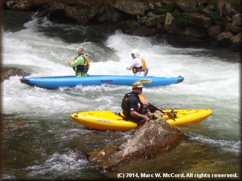
We wondered into Tennessee on Day Four for a fantastic trip on the Pigeon River, a major tributary of the French Broad, which was to be our fifth day river. For me, the Pigeon was the most exciting river we ran on this trip, not so much for the size of its rapids (Class II to III+), but rather for the sheer number and quality of them. The entire run down to the Hartford bridge was only about 4.3 miles, but it was packed with excitement.
We began the trip at the Walters Power Plant near Waterville, North Carolina and it did not take long for the fun to begin. Powerhouse Rapid (Class III+) comes just one tenth of a mile below the put-in, and serves as a wake-up call that this river is about to pull up her skirt and show you what she’s got.
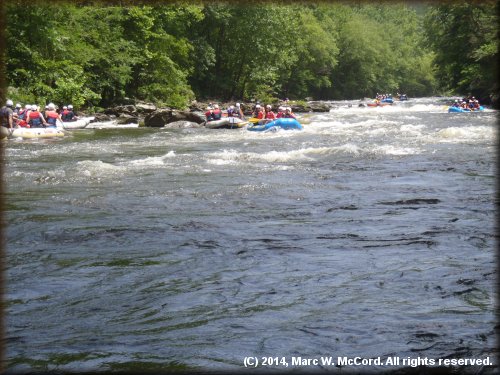 The powerhouse was releasing water that day from two turbines, so we had a fantastic flow with deep water and plenty of current to make paddling downriver easy. Tom was in his S16, Jason and Walter were in my S16 and I was in my S12 - great boats for that river! We were joined by a plethora of vacationers in commercial rafts, as well as many playboat kayakers, so there were a lot of people on the river that day, but the traffic did not slow us down or cause any disruption to our fun. We sliced and diced Powerhouse Rapid like it was child’s play, though it was a rough and wet ride that prepared us for the rest of the day.
Following Powerhouse Rapid came Big Rock (Class II, Mile 0.4), Full of Water (Class II+, Mile 0.5), Razor Rock (Class II+, Mile 0.6), Snapdragon (Class unrated, Mile 1.5), Lost Guide (Class III+, Mile 2.3 lasting about a quarter mile of non-stop excitement), Double Reactionary (Class III+, Mile 3.2) and then Accelerator (Class III+, Mile 3.3). The final mile is relatively flatwater, but extremely scenic, though IH 40 is just a few yards away on river right and parallels the river for almost the entire run. If we had the time, then we would have run the Power Plant to Hartford run one or two more times, but we had a two hour drive back to camp and it was already after noon before we launched, so we called it a day and headed for food, which is one of two reasons why we do these trips.
We will probably return to this area next year, and if so, then the Pigeon will definitely be one of the rivers we run and we will probably do more than the 4.3 miles we ran this year. If we could stage it, then I would love to run all the way to the French Broad confluence starting with empty boats and then packing for the downriver trip somewhere around the community of Denton about 12 miles below the Walters Power Plant put-in. While not as exciting as the first 3 or so miles, there are still some good rapids and excellent scenery all along the river which flows through a mostly undeveloped, densely forested area of North Carolina and Tennessee.
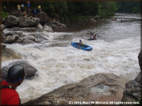
The French Broad (Section 9) was our final river for this trip because of falling water levels everywhere in the area, but we saved the "best" for last. It was not best in terms of difficulty or scenery, but because it gave us the most trouble and really tested our skills. It started with a few decent rapids and then quickly turned into a flatwater run on a wide, shallow river with a moderate headwind that had us wondering why we had even gone there. We paddled about 9.2 miles from Barnard to HotSprings . Recreational paddlers often run the good rapids, including some Class III stuff, sown to Stackhouse and then end their trip there. That misses the real challenges of the French Broad, as well as about 2.5 miles of uneventful flatwater paddling.
 At about mile 6.5 the river divides around an island with a long wave train along the left side and some real excitement along the right side. The fun starts at Kayaker Ledge about 6.7 miles below the put-in for this section. Kayaker Ledge is a Class III riverwide (on the right side of the island) drop of about 5-6 feet on its left side and perhaps 6-7 feet on its right side. We caught the Broad at about 2,500 cfs, so we ran Kayaker Ledge on river right to get the most fun. This is actually a double drop with the second one being a little shorter and easier than the first one, and none of us had any problems at all. That was about to change!
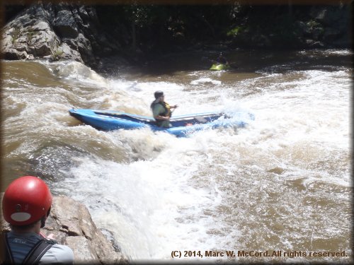
The finale was Frank Bell Rapid, a solid Class IV to IV+ double drop of about 6-7 feet each into nasty, churning whitewater punctuated by huge boulders with pour-overs and a lot of turbulence. One can hear Frank Bell loudly announcing itself from a considerable distance upstream. It is so loud that even a deaf person would hear it! After carefully scouting for nearly a half hour we determined that our ideal line would be down the far right side into the biggest hole, but avoiding the nastiest boulders. There was a problem, however, that mitigated our best intentions - the flow was too low for a clean run down the right side, so we had to enter left of center and then work our way to the bottom. THAT was the tricky part, as I was soon to discover.
Walter was paddling his Old Town Discovery 169 down the left side of the island and he experienced no problems. The rest of our group went right. Jason was the first to run and made the top drop with ease, but then took what is described as the "hero line" left of center on the second drop paddling my S16 solo. He made the drop, but then hit a huge boulder and immediately capsized, his boat corkscrewing into and under the water as it ejected him into a deep hole. Both Jason and the S16 surfaced almost immediately.
To digress for a moment, I want to put these holes into perspective. A few years ago a train lost a boxcar that derailed into Frank Bell Rapid, sank into the hole and has never been seen since. THAT is a DEEP hole! And, to make it worse, where the water pours over multiple boulders it creates a suction that takes anything that enters it down very deeply - and tries to hold it down. It is a place you do NOT want to be!
Tom ran it next in his S16 and stayed all the way to the left. He took both drops without incident and made it look easy. I was working my way to my boat after scouting and did not see Jason or Tom make their runs, so I had no idea what was in store for me, and that was my first mistake. I could have learned a LOT by watching both of them. Hindsight is 20-20.
I lined up left of center and nailed the upper drop without incident, eddied out to the left, sized up where I wanted to be for the second drop and then started paddling there with an upriver ferry angle to get my bow where it needed to be for a hard left turn to enter the second drop on the far right. I know it was going to be a testy drop, but I was confident that I could manage it, especially in my nimble S12.
As I began paddling to river right I quickly realized that the current was taking me toward the edge of the second drop faster than I was going across the river. I had three options - go over sideways (unthinkable!), pin my bow on a small boulder, spin and go over backward (even more unthinkable) or spin left and drop in looking at that beast, which is what I did. I nailed the second drop, but then hit the same boulder than flipped Jason and repeated what he did. My boat corkscrewed underwater and as I was being ejected I tried to grab my flip line, but missed it and immediately got sucked down very deeply into that hole - without very much air in my lungs. BAD situation!
I went so deep that everything was dark and I could see no daylight on the surface of the river. Realizing that I was in serious trouble I did something I NEVER do - I consciously released my $250 ZRE carbon fiber paddle so that I could use both hands to swim to the surface. It did not help. I was kicking and stroking with all my might, and I finally saw daylight, but I was still at least 4-5 feet beneath the surface and completely out of air. Involuntarily, my mouth opened and I sucked in water trying to get air. My swiftwater rescue training immediately kicked it and I spit the water out then closed my mouth. My lungs were burning and hurting, but I kept pulling for the surface.
Finally, I got my nose up just long enough to get a very short breath before I was sucked back down. I came up a second time, got another short breath and then got sucked back down. Then, I felt the hands of two kayakers grab the shoulder straps on my PFD and lift my head out of the water. They said my eyes were glazed and I was unresponsive, but I was fully aware of everything that was happening. I just needed air, and a lot of it. They asked if I was okay and I indicated that I was, but that I needed air.
Allen Freeman, who was on my right side, asked if I could hold onto the grab handle on the stern of his kayak, and I indicated that I could. I moved to the stern of his boat, took the grab handle in my right hand, and then began to kick to assist Allen in getting us to the bank - we were still in moving water and I knew he was going to struggle towing me, and he did, but he got me into shallow water near the bank where I could stand up.
Allen asked if I was all right, and I responded in the affirmative. He asked several times, and then told me the reason why he was asking was because I had a tooth missing and my mouth was bleeding. I was unaware I had ever hit anything and I felt no pain of any kind other than the pain of needing air in my lungs (and probably my brain, too!) I told him that I was fine and in no pain, and that I just needed a few minutes to get my breath so that we could continue down to the take-out at Hot Springs.
While I was recuperating Allen asked what I remembered. I told him that I tried to grab the side handle on my boat when I first flipped, missed it and went down into a very deep hole perhaps 15-20 feet beneath the surface. I told him that I consciously and intentionally released my paddle so I could use both hands to swim to the surface. He asked about my first thought upon coming to the surface and I stated that I immediately looked downriver to see if anybody had grabbed my paddle. He was amazed that I was thinking about my paddle, but those babies are expensive and after paddling with an 8.5 ounce carbon paddle I could not imagine using my 25.5 ounce AquaBound Edge (though I did have another ZRE in my boat, too. Still, losing a $250 paddle would NOT make for a great day on a river.
Allen asked if I was aware of them grabbing my PFD, and I told him that I was immediately aware of them and knew that I was going to survive as they lifted my head from the water and held me up so I could breathe. But, I was completely exhausted from that deep swim. Now, I was wearing my Patagonia Rio Grande PFD with 18 pounds 6 ounces of flotation - enough to float somebody about 60 pounds heavier than myself, but in that aerated water it was insufficient to bring me up and keep me floating on the surface.
Just before the trip I advised Jason to buy a new PFD, and the one I suggested was the MTI Headwater with 26 pounds 5 ounces of flotation - enough to float a person of about 400 pounds, which is nearly twice my weight. I intended to buy one myself, but my Patagonia is relatively new and very good, so I delayed making that purchase. Jason was up almost immediately while I stayed under for much longer than I wanted. As soon as I returned home I ordered my new MTI Headwater and I will war it on all future big water runs, tough I still prefer my Patagonia for less demanding conditions because (1) it is more than sufficient in most cases and (2) it is much cooler in warm weather conditions. If I had bought the MTI before the trip, then I have no doubt that I would have surfaced much sooner.
The current carried me nearly 1,000 feet downriver after I flipped. I was underwater much longer than I have ever been before, but my friends say it was still only a matter of a few seconds. It seemed like several minutes to me. Tom had recovered my ZRE paddle, and after a few minutes of rest and getting air I was ready to paddle to the take-out. We had one more Class II ledge just before the take-out that was no trouble at all, and then it was time to load boats and return to camp.
The following morning, at the group meeting, reports on rivers were that they were dropping rapidly and not likely to go back up, so after the meeting our group discussed the situation and then decided to pack up and head home. We had two in our group who needed to be back earlier than our intended return, we had a lot of fun, we all survived and going home was a good thing to do. My only regret is that we did not run the Ocoee on our way out, but our trailer was loaded and our SOARs were under a LOT of gear and supplies that we would have had to move, so we will save the Ocoee for a return to that area.
I want to pay a special tribute to my good friend Tom Taylor, who usually provides "entertainment" in the form of swims in big rapids for our groups. On this trip Tom was the ONLY one of us who never flipped his boat or went swimming. It may never happen again, but for five days in June and July, 2014, Tom stayed dry while the rest of us swam at least once. I had three swims - two on the Chattooga and THE swim on the French Broad. But, it was hot, I was hot and my boats were dirty, so I needed to wash them and cool off. That’s my story, and I’m sticking to it!
"
