On Thursday and Friday, January 27 and 28, 2005, I led a trip for Texas Monthly webmaster and writer Charlie Llewellin down the Sabine River between Toldeo Bend Dam and the private under-development campground of Adventure Canoeing and Outfitters of LeBlanc, Louisiana. Putting in below the spillway in a man-made channel, Charlie and I paddled about 13.6 miles on the first day to a white sand beach where we made camp a few miles below Texas SH 63 / Louisiana SH 8.
Along the way we had a great current and plenty of water due to the continual release from the hydroelectric generation on Toledo Bend Reservoir. Temperatures were in the low 50's to lower 40's most of the time, and we paddled under a solid cloud cover that afforded no direct sunlight resulting in few photo opportunities on this trip. We did, however, see bald eagles both soaring above and sitting in trees along the river banks.
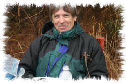
Rick Wyatt, owner of Adventure Canoeing and Outfitters in nearby LeBlanc, Louisiana, provided camping accommodations on his private property at our take-out just west of SH 111 in Vernon Parish, where he met us on Wednesday night when we arrived to camp before starting our trip the next morning. He was an excellent host and provided a good description of what we could expect on our trip, as well as sharing his knowledge about local history and the people of western Louisiana.
The next morning Rick arrived with coffee and cinnamon sweetrolls prepared by his wife Monica. We loaded our gear and boats onto Rick's truck and headed upriver, stopping at the observation tower above the dam to look downriver and take a few photos before putting in. Then, we headed for the access road beside the man-made channel on the spillway where hydroelectric generation occurs. We were greeted by a constant release from one gate that provided a steady flow of about 7,600-7,800 cfs. Coming from the dam, the water was clean, clear and cold, but it turned to its typical tannic acid brown color a short distance downriver, though it was hardly detectable except when one looked at the white blades of a paddle immersed in the river.
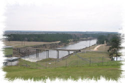
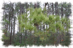
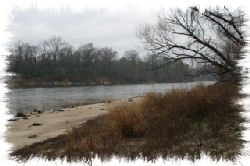
The put-in was alongside the river in a channel created for power generation where both banks were in Texas. A short distance downriver we came to the confluence of the main channel coming from the dam and began our journey down the line between Texas on river right and Louisiana on river left. All along our journey the river was marked by white sand beaches backed by forests of hardwoods and pine trees. In most places the river was at least 100 yards wide, and possibly wider - this was no small stream! The Sabine River is a flatwater stream free of rapids, ledges, pourovers and other potential hazards that would make it difficult for novice, beginner or other less experienced paddlers. In fact, just about anybody could and would enjoy paddling here for the remoteness and natural scenery all along the river corridor.
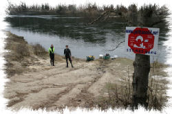
At about 10.5 miles downriver from our put-in we padded under the moderately high Texas SH 63 / Louisiana SH 8 iron bridge on the road between Burkeville, Texas and Burr Ferry, Louisiana. It was the first distinguishable landmark we encountered, and is quite easy to recognize. There were white sand beaches above and below the bridge where paddlers have the option of starting or ending trips on the Sabine, though that would require carrying boats and gear up or down a rather steep embankment that is significantly vegetated.
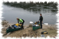
With the onset of darkness, cooler temperatures and the potential for rainfall we opted to find a camp along the river at about 5 p.m., and ended up on the Texas side about 3 miles below the iron bridge. Beaching our boats was quite easy, and we only had to carry gear a short distance up the white sand to a flat area with sparse vegetation behind a sand berm that afforded us a great campsite with a barrier against rising water during the night, event though it was not necessary. We pulled our canoes near a tree about 20 yards from the river's edge and lashed them to prevent their taking off on their own volition during the night. We set up the tent and Charlie started gathering firewood while I set up the table, stove, charcoal grill and made other preparations for cooking dinner. By 8 p.m., we were dining on grilled yellow squash, zucchini, new potatos, carrots, bell pepper and onion with oatnut bread. Not being a vegetarian, I added a grilled chicken quarter seasoned with garlic salt, chopped onion flakes, lemon pepper and Tony Cacherie Cajun spices (we WERE in Cajun country, after all!) to my fare.
Charlie turned in early and I stayed up until about 11:30, looking at the clear sky and the stars that filled it. Darkness was all around and there were no signs of city lights or noises from traffic to be heard. In fact, it was dead quiet - even the river made little sound. Sometime around 3 a.m., it began to rain. At times, it was quite heavy, but most of the time it was just steady. The sandy beach absorbed all the water and there were no pools standing around us the next morning. The rain did manage to extinguish our campfire that we intended to use for drying our wetsuits and river boots before continuing downriver, and we never got it going again. In fact, it started to rain at just about the time we were getting ready to prepare breakfast, so we just sat around in the tent and snacked on fruit while waiting out the "storm".
Around 11:30, the rains had abated and the clouds seemed to be thinning, so we made a decision to cook breakfast, strike camp and see how much farther we could make it toward our destination. We intended this to be a one-night and two-day trip, but we still have about 18.5 miles to go so we were resigned to possibly having to spend another night on the river. We departed at 12:30 p.m., and paddled steadily to get as close to our take-out as possible so that we could finish early on Saturday morning (my 57th birthday.) We continued seeing bald eagles along the river, though other forms of wildlife eluded our sight. I kept checking my GPS and saw that we were averaging between 4.2 and 6.7 mph. At that rate we had a chance to finish today. Without trying to burn ourselves out we just paddled at a steady pace and 4 hours after departing we saw our take-out on river left. Charlie was ecstatic! He had plans to do a road trip through the backwoods of East Texas for another story he was writing, and was anxious to get to it.
Since it was already late in the day we decided to haul gear and boats up the embankment, across one lot and the road to the location where our vehicles were parked, then set up camp and prepare dinner for that night. We also decided to camp there on Friday night rather than depart, as previously planned. We had basically the same meal as the previous night, though seasoned differently so that it was like a new meal to which we added potato salad and hot bread with butter. We had an excellent view of the river from our campsite, and were visited by the dog, rooster and one hen from a neighbor across the road and next door to Rick's property.
Even in January this was a great trip. Spring and fall months offer warmer weather and more sunshine, but temperatures were well above freezing and we had the river all to ourselves. During summer months one can expect to see other paddlers, especially on weekends. It is surprising that there are no Texas-based outfitters in Burkeville, Bon Weir or Jasper offering trips on this scenic river, but those in Louisiana can provide what you need for a fantastic trip of a few hours, a day or several days on a remote and naturally gorgeous river that is home to several annual trips led by members of the Big Thicket Voyageurs of southeast Texas.

