Without a doubt the single most canoed river in the world is Missouri's Current River, a 184 mile long spring-fed stream that flows from Montauk State Park in Dent County, Missouri to its confluence with the Black River in Northeast Arkansas. It drops about 620 feet over its course at a relatively flat 3.4 feet per mile, though it has a steeper gradient of about 8.7 miles above Akers Ferry. With no significant rapids and few swiftwater sweeps the Current River is well-suited to paddlers of all skill levels. In fact, it is truly a "float" stream - most people who go to the Current spend more time floating than paddling. In summer months, especially on weekends, it can be quite crowded. While you will find an occasional kayak or raft, the canoe is the preferred watercraft of choice by most paddlers on the Current River.
 Most recreational paddling is done on the 89.3 mile top half of the river from Montauk State Park to Big Spring Campground in the Ozark National Scenic Riverways area where strict limits on motorboating are in place. Below Doniphan, about 35 miles below Big Spring Campground, the river really starts to widen and slow down. Weekends often find a significant number of boats with large motors racing up and down the lower end of the river, but during the week the river is largely unspoiled. The nearest significant size town or city to the upper river is the scenic Eminence, located along the banks of the Jack's Fork River just a few miles west of the Current River and the two rivers confluence. Van Buren, located near the bottom of the Mark Twain National Forest, through which the river flows, is about 85 miles below the headwaters, which form where Pigeon Creek meets Montauk Spring.
The single most prominent feature of the Current River is the number of major springs that feed fresh water into the channel. Welch Spring enters the river on the left about 14 miles downstream from the headwaters, nearly doubling the flow of the river. Other notable springs include Cave Spring (river left at about 23 miles), Pulltite Spring (river right at about 27 miles), Round Spring (river right at about 37 miles), Ebb and Flow Spring (river left at about 50 miles - just above the Jack's Fork confluence), Blue Spring (river left at about 60 miles), Gravel Spring (river left at about 68 miles), Watercress Spring (river left at about 86 miles), Big Spring (river right at about 91 miles), Cave Spring (river left at about 100 miles - this is the second spring with this name) and Panther Spring (river right at about 102 miles.) Big Spring alone feeds about 470 cubic feet per second (cfs) into the Current's flow. The Jack's Fork River, the principle tributary to the Current River, flows in about 51 miles below Montauk State Park adding a significant amount of water to the river. In addition to keeping the river flowing year round, the 58-60° waters prevent freezing in winter so paddlers can enjoy the Current River at any time, though the Ozarks can get rather chilly in winter. But, the cool waters are refreshing and inviting in the heat of the summer, which is one of the many attractions that lure so many people there.
Many of the springs are interesting places to stop and see. Photographic opportunities abound, and a quick dip will tell you that the water is cooler in the springs than in the main channel of the river itself. Wading, swimming and boating are prohibited in several of the major springs because such activities pose a threat to the health of the ecosystems of those springs. Posted signage tells you if such activities are prohibited - please obey them to keep the springs vibrant and healthy. But, since most are within a few yards of the river bank it is worth the small effort to stop and take a look at where the Current River gets its perpetual flow.
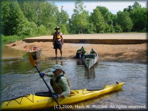
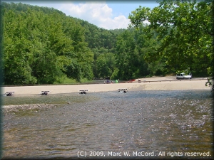
The Current River flows through the Mark Twain National Forest all along its course down to Gooseneck Public Access and is controlled by the US Forest Service which maintains numerous excellent campgrounds along the river all the way down to Gooseneck about 20 miles below Van Buren. While Montauk State Park's Tan Vat Access is the highest access point most paddlers begin trips at or below Baptist Camp Access about 1.2 miles below. Above the park the Current River is actually just a very small stream named Pigeon Creek which becomes wider and deeper with the inflow from Montauk Spring in the state park where the Current River comes to life. There are a total of 26 public access points between Montauk State Park and Doniphan over a distance of about 124.1 miles of gorgeous river of which about 106 miles flows through the Ozark National Scenic Waterway. There are many outfitters located along or very near the river, so finding canoe rentals and shuttles is quite easy.
 At about 7.5 miles below Tan Vat Access (Montauk State Park) a low-water bridge on CR 651/CR 650 spans the river forcing a mandatory portage which is easiest on river right. The bridge features several culverts that could be dangerous in high water conditions, but which pose little risk at normal flows. The landing on the downriver side of the bridge makes an excellent place to stop for a break or lunch before continuing the trip downriver. It is popular with local residents who go there to swim and relax in the cool water. Grates over the inlets of the culverts prevent boats and boaters from being sucked under the bridge, but strong currents could pin a boat or person, so exercise caution when approaching the bridge, which is clearly visible for at least one tenth of a mile.
In low-water conditions starting above Welch Spring can be somewhat problematic in that you may have to walk and carry or drag boats occasionally, though not very far - usually a few feet or yards - before being able to paddle again. The longest distance between two access points is the last 14 miles between Doniphan and the Arkansas state line followed by the 12.4 miles between Round Spring Access and Jerktail Landing. The shortest distance is the 1.2 miles between Tan Vat Access and Baptist Camp Access followed by the 1.5 miles between The Sinks Access and Round Spring access. Other distances between access point range between these extremes with the average being about 7-8 miles, so trips of many lengths can be taken depending upon water conditions and paddler preferences. Many people specifically start and end trips to allow them to visit a spring since the scenery around each one is so spectacular.
While the river is most popular down to around Van Buren it is navigable all the way to its confluence with the Black River in northeastern Arkansas. Other than an undammed pool named Goose Lake, where the river widens and slows, it flows at a respectable rate. The last take-out in Missouri is Currentview on the Missouri-Arkansas state line about 14 miles below the T.L. Wright Memorial Access at Doniphan. Between the US Forest Service and Missouri Department of Conservation incredible effort has been made to create and maintain good quality public access points to promote recreational enjoyment of the Current River, which is partly responsible for the popularity of the river. Of course, those access points exist specifically because of the popularity of this stream.
 Welch Spring, located on river left about 14 miles below the state park, is the first major spring along the river, and it is very popular with visitors. Flowing out of a rock cliff into a large pool just a few yards northeast of the river channel, it is highly visible and easy to access by walking in from the river or on land. Its cool, green water is beautiful to look at and very refreshing on a hot day. In fact, it feels downright cold in mid-summer when water temperature can be 40°+ below the air temperature in the upper 90's to 100's.
Excellent campsites, both natural and in commercial or NPS campgrounds, are abundant all along the Current River. In summer months competition for campsites can be formidable, and reservations are definitely recommended for the developed campgrounds on weekends, and especially around holiday weekends. You could get lucky without a reservation, but I would not count on it - the Current River is VERY popular, and many people go there for more than just a day trip, though most base camp rather than hauling gear downriver in their canoes. Most people on and along the river are very friendly, and even with the crowds in summer it is a peaceful and pleasurable place to enjoy a river. In the off season it is all but deserted, and if you go between the middle of September and early May you may well have the entire river to yourself.
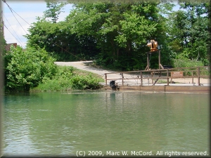 Akers Ferry, which is about 15.8 miles below the state park, is located where Highway K from the southwest meets Highway KK from the northeast. There is no bridge spanning the river, and drivers have the option of a long drive around or a reasonably priced ($4.00) ferry across the river on a motorized barge that is not in continuous operation. Akers Ferry is the last remaining operational river ferry in the Ozark National Sceneic Riverways. The ferry operates during daylight hours, though I have never actually seen it in operation.
In addition to the many springs that feed the Current River it is also home to numerous large caves, several of which are open to the public for sightseeing and exploration. These features add a different dimension to visits to the river, and while some are only accessible by boat others can be walked to on dry land. The Mark Twain National Forest provides a green canopy of dense foliage to the river banks and surrounding lands. The whole Ozark topography is an awesome sight any time of year, but especially from late-March through November when temperatures are moderate, though hot in summer, and the colors of the flora and fauna erupt to life and then change into their late-fall pallette before the onset of winter.
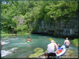
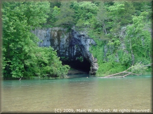 Cave Spring is a prominent and obviously visible feature along the river. Paddlers can actually canoe or kayak into the cave a short distance, but the spring itself is not readily visible - it gets dark in there pretty quickly. Still it makes a great backdrop for photos of boaters emerging from the cave.
Pulltite Campground, on river left, is an excellent USFS park just upstream and on the opposite side of the river from Pulltite Spring located just a few yards off the river channel. It is usually necessary to land your boat and walk up Pulltite Branch to the spring because the water is too low to paddle up to the spring. Adjacent to the spring is the Pulltite cabin, another prominent landmark along the river.
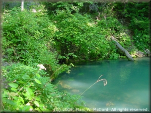 About 8 miles below Pulltite Spring is Round Spring Access, spring, campground and cavern, a very popular stopping off point for a brief visit or for overnight camping if continuing downriver. Many trips start or end at Round Spring because of its easy access and convenient amenities. The beautiful, blue-green water is indicative of the depth of the spring pool, and it has a gorgeous run-out branch from the spring down to the river.
Big Creek flows into the Current River on the left about 8.3 miles below Round Spring. Bee Bluff is on the left about 2 miles further downriver and Jerktail Landing, a popular access point and campsite, is on river right about another two miles downriver. If camping at Jerktail do NOT believe anybody who tells you that a 5" rain will flood the campsites 15 feet above the river - it will not happen!
Ebb and Flow Spring is located about a quarter mile off the river on the left about 4.5 miles below Jerktail Landing, and it is worth the short hike to see it. About 0.4 miles below Ebb and Flow Spring is the Jack's Fork River confluence. The Current River starts widening above the confluence and gets substantially larger at the confluence. Two Rivers Access is located on river right just below the confluence, and is the popular take-out for Jack's Fork trips, as well as for some Current River trips. It's close proximity to Eminence makes it very convenient as a point for re-stocking if continuing on downriver, and there is a country store on the river left side of the Jack's Fork River that makes awesome hamburgers and potato wedges if you are in the market for something good during or after a river trip.
Blue Spring, Missouri's ninth largest spring, is on river left about 8.5 miles below the Two Rivers confluence, and it is definitely a place worth seeing. It has deep blue water, spectacular ferns and other natural foliage and is as easily accessible from land as from the river. Several other excellent access points and campgrounds are located between Blue spring and Doniphan, all of which allow customizing your trip to meet your needs. Though most paddlers never see the lower middle and lower sections of the river they are special places that you should go if you have the time.
I always look forward to a trip back to the Current (and Jack's Fork) River. What it lacks in whitewater excitement is more than offset by its immense natural beauty and nearly perpetual navigable flows. For me, winter trips are as much fun, though a lot colder, than summer trips, and every bit as interesting without the crowds. In fact, you will probably not see many people at all outside the normal season of May through September.
