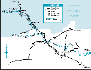
Rising in the Ouachita Mountains of Montgomery County in west central Arkansas flows the Caddo River, a Class I-II moderate whitewater river that runs close to or through Black Springs, Norman, Caddo Gap, Glenwood and Amity on its way to the backwaters of De Gray Lake. The river forms southeast of Mena and west of Norman, then flows in a generally easterly direction into Norman where it turns southeast to Amity, and then back to the east into DeGray Lake. From there, the river flows a few miles down to its confluence with the Ouachita River just east of Caddo Valley and north of Arkadelphia. The total length of the river is about 82 miles including the distance across DeGray Lake, which is formed by damming the river. It is a typical pool-and-drop river that is gentle enough for novice paddlers, yet with enough whitewater excitement to entertain those who prefer a bumpy ride over flatwater.
At high water levels the Caddo River is navigable above the Town of Norman, but the flow will be very fast and potentially dangerous for inexperienced paddlers. The first practical access point is the SH 8 Bridge about 11.6 river miles west of Norman where parking is VERY limited and access is not improved. Four other potential acess points are located between the first one and Norman. At normal water levels the river above Norman is generally not a place to go, as the flow will be insufficient for good trips. Starting at the uppermost practical access gives you a run of about 47.42 miles down to DeGray Lake.
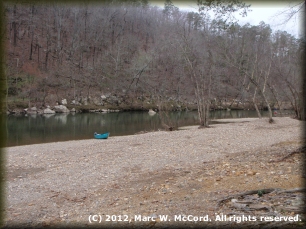
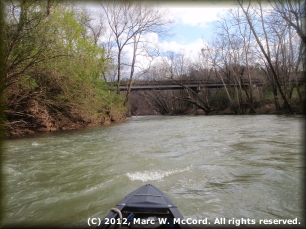
The most commonly used put-in is at the public access in Norman, usually ending 30.1 miles later at the State Highway 84 crossing northeast of Amity, though it is possible to paddle all the way to De Gray Lake another 11 miles downriver. Between Caddo Gap and Glenwood lies an 8-mile stretch with rock gardens that are fun in high water, but which will stop a boat when the water runs low. Along the west bank (river right), in the area known as Caddo Gap, hot springs bubble up into the river at or just below the surface. The thermal waters create a sensation uncommon on most rivers. Small rapids, long gravel bars, willow thickets and the Caddo Gap, a narrow opening where the river flows between ridges on either side, define the river approach to Glenwood.
From Glenwood to Amity the river has many similar characteristics, but the current slows as the rapids become tamer and the pools lengthen. The riverbed consists of gravel well rounded from the flow of the river over many years, and good gravel bars along the riverbanks make excellent primitive campsites for overnight trippers. As with most Arkansas streams, the Caddo River is seasonal, running best from March through June, very low and slow during the summer, and marginal the rest of the year except right after heavy local rainfall. Scenery along the river is excellent, with heavily forsted ridges, rock outcroppings, translucent green water, an abundance of native animal and plantlife, and excellent fishing.

Montgomery, Pike and Clark Counties in west central Arkansas on the southern edge of the Ouachita Mountains and just north of the Cossatot, Saline, Little Red and Little Rivers.

Hot Springs 46 miles; Little Rock 102 miles; Texarkana 107 miles; St. Louis 456 miles; Springfield 302 miles; Memphis 236 miles; Dallas 280 miles; Austin 465 miles; San Antonio 544 miles; Houston 403 miles; Oklahoma City 283 miles; Albuquerque 825 miles; Phoenix 1,288 miles; Denver 912 miles; Salt Lake City 1,434 miles (all distances are approximate and depend upon starting point (referenced to Norman), destination point on the river and route taken.)

Excellent, clean, cold and clear, with a translucent green color as it comes out of the Ouachita Mountains. Flows are very low in summer months, marginal in fall and winter months and best in the March to August or September period. Adequate water for paddling may be found after heavy local rainfall. Average flow is about 267 cfs (5.84 feet) on the Caddo Gap USGS gauge. Optimum flow above US Highway 70 Bridge for experienced paddlers is about 448 cfs (6.25 feet) to about 1,200 cfs (7.5 feet). At flows above 1,200 cfs (7.5 feet) on experienced boaters with advanced or expert whitewater skills should attempt to run the Caddo River due to tricky currents, strainers and other potential hazards that demand instant decision making and quick reflexes.
NOTE: Outfitters may opt not to provide rentals or shuttles when flows exceed about 578 cfs (6.5 feet) due to increased risk to customer safety and the likelihood of lost or damaged boats, paddles and other gear.

March through August or September usually has plenty of water for paddle trips, but other times may not be as good, depending upon how much rain is falling in the drainage basin. Winters can be very cold and summers will be warm, with low water in most cases.

There are no significant hazards at normal or low water levels. There are numerous Class I to I+ rock garden rapids that can become a hazard, particularly for inexperienced boaters, at high water levels. Strainers in swift currents around river bends are the greatest threat to safety. Most of the rapids will be found between Caddo Gap and Glenwood, in an 8-mile stretch, and down between the SH 182 and SH 84 bridges.

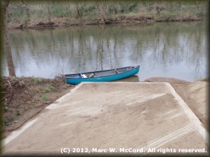
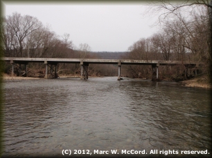
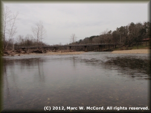
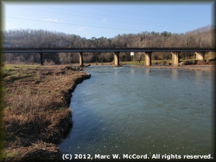
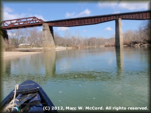
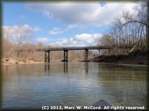
SH 8 Bridge (N34° 26' 55.01" / W 093° 50' 05.24") west of Norman SH 8 Bridge at 0.0 miles (High water ONLY!); SH 8 Bridge (N34° 26' 59.47" / W 093° 47' 27.02") west of Norman SH 8 Bridge at 3.1 miles (High water ONLY!); Forest Service Road 73 (N34° 26' 53.95" / W 093° 46' 56.87") west of Norman running north from Montgomery CR 10 at about 3.65 miles; Mt. Gilead Church Road (CR 259) (N 34° 27' 02.39" / W 093° 45' 16.45") west of Norman between CR 10 and SH 8 at about 5.8 miles; River Road (N 34° 27' 20.58" / W 093° 42' 52.08") west of Norman at about 8.7 miles; Norman Public Access (N 34° 27' 34.10" / W 093° 41' 35.19") off SH 8 in Norman on river left at 11.6 miles; Possible private property access off SH 8 (N 34° 25' 42.98" / W 093° 38' 21.80") on river left at about 16.14 miles; Caddo Gap Public Access (N 34° 24' 00.44" / W 093° 37' 18.58") on river left at 18.18 miles; Caddo River Camping & Canoeing private access (fee required) on river left at about 20.0 miles; SH 240 Bridge (N 34° 22' 59.35" / W 093° 36' 20.05") on river left at about 20.18 miles; Caddo River Camping & Canoeing private access (fee required) on river left at about 27.34 miles (just before the US Hwy. 70 Bridge); US 70 Access (N 34° 19' 17.82" / W 093° 33' 08.90") in Glenwood off SH 8 South at about 27.35 miles; Caddo River Camping & Canoeing private access (fee required) on river right at about 27.36 miles (immediately after the US Hwy. 70 Bridge); Glenwood City Park access (N 34° 19' 14.06" / W 093° 32' 29.47") on 3rd Street south of US Hwy. 70 on river left at about 28.82 miles; SH 182 old low-water bridge (N 34° 17' 24.15" / W 093° 27' 31.48") north of Amity on river left just below bridge at 36.65 miles; SH 84 Bridge access (N 34° 17' 08.57" / W 093° 25' 05.62") above bridge northeast of Amity on river right (very rough and difficult access from river to parking area) at 41.7 miles (last PRACTICAL take-out above lake); SH 346 boat ramp (N 34° 15' 44.49" / W 093° 21' 19.27") on river left at headwaters to DeGray Lake at about 47.41 miles; Other accesses are available on De Gray Lake at about 50.0 and 52.7 miles.

Caddo River Camping & Canoe Rental (1-888-300-8452), located at 26 Highway 8 East and the Caddo River in Glenwood, Arkansas, offers tent and RV camping with a small camp store, hot and cold showers and other amenities, as well as a bunkhouse for rent, along the Caddo River. Campsites are available at the Crystal Recreation Area north of Norman off Forest Road 177 (off the river). There are abundant gravel bars along the riverbanks that offer excellent primitive campsites. All land along the Caddo River is privately owned, and landowners cherish their privacy, so avoid camping above the riverbanks unless you have first obtained permission. Camping, cabin rentals and other accommodations are also available from any of several commercial facilities on or near this reach of the Caddo River.

Caddo River Camping & Canoe Rental (1-888-300-8452), located at 26 Highway 8 East and the Caddo River in Glenwood, Arkansas, offers canoe and kayak rentals, shuttles and other services on the banks of the Caddo River. There is at least one other commercial outfitter offering rentals, shuttles and/or river information for this reach of the Caddo River.

The Caddo River is a frequently paddled destination of immense natural beauty, characterized by moderate water most of the time and a short to medium length season of about three to six months months when the flow is usually adequate for good trips with minimal to no dragging. The river is, however, occasionally navigable even in winter, depending upon recent local rainfall. Public access is great making getting to and from the river easy.
The area is largely undeveloped, though recent new houses have begun appearing, as the river cuts through the southern Ouachita Mountains of the Ozarks where wildlife and plantlife are abundant. Fishing for walleye, white, spotted, largemouth and smallmouth bass, crappie, longear and other species of sunfish and channel, blue and flathead catfish is excellent. The water is great for swimming, though it will tend to be a little cold for many people. Recent floods have flattened some of the rapids so that they are not as challenging as they once were (and as they WILl be again after future floods alter the river.) Hot springs feeding the river between Caddo Gap and Glenwood are an attraction seldom seen on rivers. The river flows just a few miles north of the famous Cossatot, Saline, Ouachita, Little Missouri Red and Little Red Rivers, and is close enough for a side trip (by car, of course) to Hot Springs National Park.
While trips can end at the SH 84 Bridge (or even further downriver on DeGray Lake) paddlers should be advised that the SH 84 takeout is VERY difficult. It consists of large, broken and uneven rocks lining the river bank, and you have to drag or carry your boats up an embankment of about 15-20 feet to the parking area. Unless you are prepared for a workout it is best to end trips at either the US Highway 182 Bridge north of Amity, or else paddle on down to one of the access points on the lake.