|
 |
|

The Rio Grande rises in Rio Grande National Forest, San Juan County, Colorado (at 37�47' N, 107�32' W), as a clear, spring and snow-fed mountain stream 12,000 feet above sea level. Its origin is at the Continental Divide in the San Juan Mountains. The river cuts through the middle of New Mexico to the site of El Paso and Ciudad Juarez, at the junction of Chihuahua and Texas. At that point, because of the Treaty of Guadalupe Hidalgo (1848), which terminated the Mexican War, the Rio Grande becomes the international boundary between the United States and Mexico. It forms the western or southern border of the Texas counties of El Paso, Hudspeth, Presidio, Brewster (where the river's sweeping curve gives Big Bend National Park its name), Terrell, Val Verde, Kinney, Maverick, Webb, Zapata, Starr, Hidalgo, and Cameron. The river empties into the Gulf of Mexico (at 25�57' N, 97�09' W). The Rio Grande has been known by many names over time and in different parts of its course. The Pueblo Indians called it Posoge (sometimes spelled P'Osoge), which meant "big river." The expedition of Hernando de Alvarado called it Rio de Nuestra Senora in 1540. It was called the River of May by three British sailors in 1568; in 1581 the Agustin Rodriguez expedition called it the Rio de Nuestra Senora de la Concepcion and the R�o Guadalquivir. By 1598 the Spanish were calling its lower course the Rio Bravo, and in modern Mexico it is still known by that name or as the Rio Bravo del Norte (bravo denotes "wild, bold, turbulent, restless"). In 1582 an expedition headed by merchant Antonio de Espejo traveled the Rio Conchos to its mouth on a river he called Rio del Norte ("River of the North") and Rio Turbio ("Turbulent River"). Juan de Onate is thought to have been the first to call it the Rio Grande, when in 1598 he reached its banks near the site of future El Paso. These names were later consolidated to Rio Grande del Norte. It was the Rio Grande that Fernando del Bosque (see BOSQUE-LARIOS EXPEDITION) named the Rio de San Buenaventura del Norte in 1675, and that Father Damian Massanet may have called the Rio Ganapetuan in 1691. The river was also called the Rio Caudaloso ("carrying much water"), and on a 1700 map it appeared as Rio del Norte y de Nuevo Mexico.
 The Rio Grande was never explored as a single unit by any one person or group. Alvar Nunez Cabeza de Vaca is believed to have crossed it in 1535 or 1536, and Francisco Vazquez de Coronado in 1540. Spanish Governor Juan Bautista de Anza examined it in 1779, as did Zebulon Montgomery Pike in 1806 and John Charles Fremont in 1849. However, the river was not well mapped before the extensive work of the American and Mexican boundary commissions made necessary by the Treaty of Guadalupe Hidalgo in 1848 and again by the Gadsden Purchase of 1853-54. Maj. William Hemsley Emory and Jose Salazar y Larregui served as boundary commissioners for the United States and Mexico, respectively, during the second survey. The Rio Grande was never explored as a single unit by any one person or group. Alvar Nunez Cabeza de Vaca is believed to have crossed it in 1535 or 1536, and Francisco Vazquez de Coronado in 1540. Spanish Governor Juan Bautista de Anza examined it in 1779, as did Zebulon Montgomery Pike in 1806 and John Charles Fremont in 1849. However, the river was not well mapped before the extensive work of the American and Mexican boundary commissions made necessary by the Treaty of Guadalupe Hidalgo in 1848 and again by the Gadsden Purchase of 1853-54. Maj. William Hemsley Emory and Jose Salazar y Larregui served as boundary commissioners for the United States and Mexico, respectively, during the second survey.
The French, on the basis of La Salle's accidental landing on the Texas coast, made half-hearted attempts to claim that Louisiana extended to the Rio Grande. The claim was still mentioned as late as 1803, the time of the Louisiana Purchase, and was not definitely renounced until the Adam-Onis Treaty of 1819, though for more than two centuries the Rio Grande had been claimed by Spain, which had exercised considerable control of the river during much of that time. In 1836, Texas put forth a claim, which set aside the documentary testimony of more than a century, for the Rio Grande from mouth to source as the southwestern and western boundary of the state. Stephen F. Austin, writing as Secretary of State of the Republic of Texas to William H. Wharton, who was in the United States attempting to secure annexation for Texas, instructed Wharton to compromise on the southwestern boundary if he thought such a move would help get Texas into the Union. During the republic, little settlement was made below the Nueces; the Rio Grande was never actually under Texan control until authority was established by Gen. Zachary Taylor at the beginning of the Mexican War. The Rio Grande was finally recognized by Mexico as the Texas boundary in the treaty of Guadalupe Hidalgo.
 Depending on how it is measured, the Rio Grande is the twenty-second longest river in the world and the fourth or fifth longest in North America. It drains more than 40,000 square miles in Texas alone. In the late 1980s the population along its banks exceeded five million. The river flows for 175 miles in Colorado and 470 miles in New Mexico. Though the length from its headwaters in Colorado to the Gulf of Mexico varies as its course changes, in the late 1980s, according to the International Boundary and Water Commission, its total length was 1,896 miles. The official border measurement ranges from 889 to 1,248 miles, depending on how the river is measured. In a sense, the Rio Grande is two streams. It dwindles to nearly nothing at Presidio, and only water from the Rio Conchos, coming out of Mexico, sustains its journey to the Gulf. Its principal tributaries are the Pecos, Devils, Chama, and Puerco rivers in the United States, and the Conchos, Salado, and San Juan in Mexico. Major cities and towns alongside the river are Santa Fe, Albuquerque, Socorro, Truth or Consequences, Mesilla, and Las Cruces in New Mexico; and El Paso, Presidio, Del Rio, Eagle Pass, Laredo, Rio Grande City, McAllen, and Brownsville in Texas. In Mexico the primary towns and cities are Ciudad Juarez, Ojinaga, Ciudad Acuna, Piedras Negras, Nuevo Laredo, Camargo, Reynosa, and Matamoros. Mexican states bordered by the Rio Grande are Chihuahua, Coahuila, Nuevo Leon, and Tamaulipas. In 1980 Ciudad Juarez was the largest city on the Rio Grande as well as on the international boundary, and El Paso, Texas, was the second largest city on the border. The two cities would constitute one of the world's major metropolitan areas if the Rio Grande did not divide them. Depending on how it is measured, the Rio Grande is the twenty-second longest river in the world and the fourth or fifth longest in North America. It drains more than 40,000 square miles in Texas alone. In the late 1980s the population along its banks exceeded five million. The river flows for 175 miles in Colorado and 470 miles in New Mexico. Though the length from its headwaters in Colorado to the Gulf of Mexico varies as its course changes, in the late 1980s, according to the International Boundary and Water Commission, its total length was 1,896 miles. The official border measurement ranges from 889 to 1,248 miles, depending on how the river is measured. In a sense, the Rio Grande is two streams. It dwindles to nearly nothing at Presidio, and only water from the Rio Conchos, coming out of Mexico, sustains its journey to the Gulf. Its principal tributaries are the Pecos, Devils, Chama, and Puerco rivers in the United States, and the Conchos, Salado, and San Juan in Mexico. Major cities and towns alongside the river are Santa Fe, Albuquerque, Socorro, Truth or Consequences, Mesilla, and Las Cruces in New Mexico; and El Paso, Presidio, Del Rio, Eagle Pass, Laredo, Rio Grande City, McAllen, and Brownsville in Texas. In Mexico the primary towns and cities are Ciudad Juarez, Ojinaga, Ciudad Acuna, Piedras Negras, Nuevo Laredo, Camargo, Reynosa, and Matamoros. Mexican states bordered by the Rio Grande are Chihuahua, Coahuila, Nuevo Leon, and Tamaulipas. In 1980 Ciudad Juarez was the largest city on the Rio Grande as well as on the international boundary, and El Paso, Texas, was the second largest city on the border. The two cities would constitute one of the world's major metropolitan areas if the Rio Grande did not divide them.
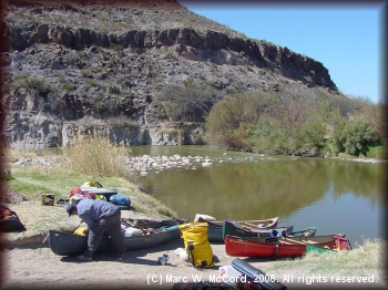
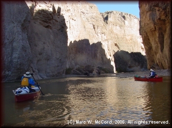
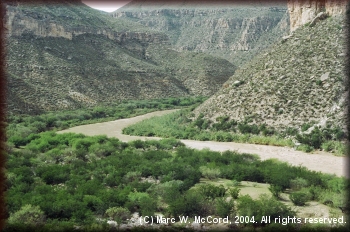
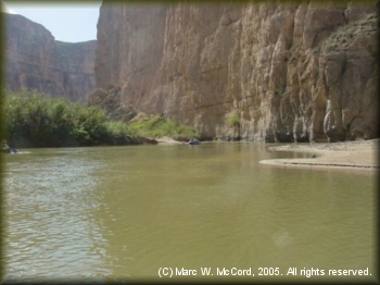 Principal crops vary along the river. Colorado and northern New Mexico grow potatoes and alfalfa. Southern New Mexico and West Texas specialize in cotton, peppers, onions, and pecans. The lower Rio Grande valley raises citrus fruits, vegetables, and cotton. Agriculture and cattle raising are the leading industries along the entire Rio Grande, although maquiladoras are rapidly becoming the leading employer, especially in Mexico. The Rio Grande has never been navigable except near its mouth and, on rare occasions, to Laredo. From the San Juan Mountains in Colorado to Albuquerque, New Mexico, it is primarily a torrent flanked by spectacular gorges and mountain slopes. South of Albuquerque, however, the land flattens and supports desert flora - mesquite, creosote brush, cactus, and yucca. The water is impounded behind Elephant Butte and Caballo dams near Truth or Consequences, New Mexico, and the river downstream is used for irrigation in the Mesilla Valley of New Mexico and the ninety-mile-long El Paso-Juarez valley, the oldest irrigated area in the state. In this valley are Ysleta, Socorro, and San Elizario, the three oldest towns in Texas. Sixty thousand acre-feet of irrigation water is annually promised by treaty to Mexican farmers near Juarez, although during periods of low snow melt-off in Colorado, this figure is reduced proportionately. At Presidio the Rio Conchos enters the nearly empty Rio Grande channel and races toward the canyonlands of the Big Bend National Park. A 191.2-mile strip of the American bank called Rio Grande Wild and Scenic River begins in Big Bend National Park and runs downstream to the Terrell-Val Verde county line. The area is administered by the National Park Service, though without federal facilities. The area had 525 daily visits and 4,329 overnight stays in 1990. South of Redford (formerly Polvo), the Bofecillos Mountains and the Chihuahua Mountains converge to form Colorado Canyon. From there the churning Rio Grande cuts through Santa Elena, Mariscal, and Boquillas Canyons. Ahead still are smaller, white-water canyons such as Horse, Big, and Reagan Canyons. Below Del Rio, Eagle Pass, and Laredo the Rio Grande skirts huge cattle ranches and farms. Broad, open valleys are the rule. The river is meandering, brown, sluggish. The scenery becomes tropical and extremely fertile; citrus groves are prominent. The river terminates in a delta at the Gulf. All along the border, and especially in the lower Rio Grande valley, bancos have been a serious problem. These wide, usually brushy curves shaped like horseshoes or oxbows have frequently overflowed and formed new channels. Defining the exact international border became a serious issue not solved until the banco treaty of 1905. Principal crops vary along the river. Colorado and northern New Mexico grow potatoes and alfalfa. Southern New Mexico and West Texas specialize in cotton, peppers, onions, and pecans. The lower Rio Grande valley raises citrus fruits, vegetables, and cotton. Agriculture and cattle raising are the leading industries along the entire Rio Grande, although maquiladoras are rapidly becoming the leading employer, especially in Mexico. The Rio Grande has never been navigable except near its mouth and, on rare occasions, to Laredo. From the San Juan Mountains in Colorado to Albuquerque, New Mexico, it is primarily a torrent flanked by spectacular gorges and mountain slopes. South of Albuquerque, however, the land flattens and supports desert flora - mesquite, creosote brush, cactus, and yucca. The water is impounded behind Elephant Butte and Caballo dams near Truth or Consequences, New Mexico, and the river downstream is used for irrigation in the Mesilla Valley of New Mexico and the ninety-mile-long El Paso-Juarez valley, the oldest irrigated area in the state. In this valley are Ysleta, Socorro, and San Elizario, the three oldest towns in Texas. Sixty thousand acre-feet of irrigation water is annually promised by treaty to Mexican farmers near Juarez, although during periods of low snow melt-off in Colorado, this figure is reduced proportionately. At Presidio the Rio Conchos enters the nearly empty Rio Grande channel and races toward the canyonlands of the Big Bend National Park. A 191.2-mile strip of the American bank called Rio Grande Wild and Scenic River begins in Big Bend National Park and runs downstream to the Terrell-Val Verde county line. The area is administered by the National Park Service, though without federal facilities. The area had 525 daily visits and 4,329 overnight stays in 1990. South of Redford (formerly Polvo), the Bofecillos Mountains and the Chihuahua Mountains converge to form Colorado Canyon. From there the churning Rio Grande cuts through Santa Elena, Mariscal, and Boquillas Canyons. Ahead still are smaller, white-water canyons such as Horse, Big, and Reagan Canyons. Below Del Rio, Eagle Pass, and Laredo the Rio Grande skirts huge cattle ranches and farms. Broad, open valleys are the rule. The river is meandering, brown, sluggish. The scenery becomes tropical and extremely fertile; citrus groves are prominent. The river terminates in a delta at the Gulf. All along the border, and especially in the lower Rio Grande valley, bancos have been a serious problem. These wide, usually brushy curves shaped like horseshoes or oxbows have frequently overflowed and formed new channels. Defining the exact international border became a serious issue not solved until the banco treaty of 1905.
Elephant Butte Dam in New Mexico opened in 1916 and was to provide a steady supply of irrigation water on demand. In 1933, the United States and Mexico approved the Rio Grande Rectification treaty, which essentially straightened the channel east of El Paso. The length of this part of the river was reduced from 155.2 miles to 85.6 miles, and the era of King Cotton and economic prosperity began. The subsequent Rio Grande Canalization Project straightened the Rio Grande in New Mexico from Caballo Dam south to the Texas line, roughly 100 miles. Significant agricultural help arrived for Southwest Texas in 1932, when the United States and Mexico agreed on the Lower Rio Grande Valley Flood Control Project. It strengthened and raised levees and dredged the channel and floodways. The Mexican-United States Treaty of February 3, 1944, committed both countries to the construction of two Rio Grande dams: Falcon and Amistad. The reservoirs were designed for storage capacities of five million or more acre-feet. Presidents Dwight D. Eisenhower and Aldolfo Ruiz Cortines dedicated Falcon Dam in October 1953. It is fifty miles downstream from Laredo, Texas. Not far downstream is Mission Reservoir, at Mission, Texas. Amistad (Friendship) Dam was finished in 1969 and is twelve miles northwest of Del Rio.
 At El Paso the Rio Grande caused friction in the 1870s, when the river bit deep into the banks of Mexico and gradually transferred land to the United States. The famous Chamizal dispute was not settled until 1963, when 437 acres was ceded from downtown El Paso to Mexico. The agreement economically strengthened both cities. The international border at the two cities is now lined with concrete so that the river will never again shift its channel. A similar, but not well-publicized, incident over boundary differences took place at the twin cities of Presidio and Ojinaga. It was settled by a 1970 treaty with Mexico authorizing a land swap called the Ojinaga Cut (or Tract), which totaled 8.3 miles. Texas gave up 1,606.9 acres and Mexico 252 acres. The treaty also provided for an international floodway of fifteen miles to stabilize the border further. At El Paso the Rio Grande caused friction in the 1870s, when the river bit deep into the banks of Mexico and gradually transferred land to the United States. The famous Chamizal dispute was not settled until 1963, when 437 acres was ceded from downtown El Paso to Mexico. The agreement economically strengthened both cities. The international border at the two cities is now lined with concrete so that the river will never again shift its channel. A similar, but not well-publicized, incident over boundary differences took place at the twin cities of Presidio and Ojinaga. It was settled by a 1970 treaty with Mexico authorizing a land swap called the Ojinaga Cut (or Tract), which totaled 8.3 miles. Texas gave up 1,606.9 acres and Mexico 252 acres. The treaty also provided for an international floodway of fifteen miles to stabilize the border further.
BIBLIOGRAPHY: Ira G. Clark, "The Elephant Butte Controversy: A Chapter in the Emergence of Federal Water Law," Journal of American History 61 (March 1975). Eagle Lake Historical Committee, A History of Eagle Lake (Austin: Eakin Press, 1987). William Hemsley Emory, Report on the United States and Mexican Boundary Survey (2 vols., Washington: Nicholson, 1857, 1859; rpt., Austin: Texas State Historical Association, 1987). William H. Goetzmann, Exploration and Empire: The Explorer and the Scientist in the Winning of the American West (New York: Knopf, 1966). Paul Horgan, Great River: The Rio Grande in North American History (2 vols., New York: Holt, 1954; 4th ed., Austin: Texas Monthly Press, 1984). Jerry E. Mueller, Restless River (El Paso: Texas Western Press, 1975). Rio Grande River Scrapbook, Barker Texas History Center, University of Texas at Austin. Charles A. Timm, The International Boundary Commission (Austin: University of Texas Press, 1941). Robert M. Utley, International Boundary: United States and Mexico (Santa Fe: National Park Service, Southwest Region, 1964). Vertical Files, Barker Texas History Center, University of Texas at Austin.
Leon C. Metz
Handbook of Texas Online, s.v. "RIO GRANDE" |
|

