The Verde River forms at Sullivan Lake, where Big Chino Wash and Williamson Valley Wash merge south of Paulden in the Big Chino Valley of Yavapai County, then flows south by southeast about 170 miles to its Salt River confluence just northeast of Scottsdale and Phoenix. Along the way, it passes through parts of three national forests (Prescott, Cococino and Tonto), the cities of Cottonwood, Clarkdale and Camp Verde, and lands belonging to various tribes of the Apache Nation, private landowners and the State of Arizona. It is a perennial stream in a state known for its "dry" rivers, but it is not always boatable, and may have navigable flows in some reaches when others are too low to paddle. Its waters come from snowmelt in the mountains around the three forests, as well as seasonal monsoons. Surrounding lands are vastly disparate in nature, ranging from densely-forested upland plateaus to canyons to desert lowlands, each with its own diverse plantlife, animals, birds and fish. Beginning about 70 miles below the headwaters is a reach of 40.5 miles that is designated as "Wild and Scenic" by the US Congress, where the river and surrounding lands are perpetually protected against development and overuse.
The Verde River flows about 46 miles between its headwaters and Perkinsville as a Class I to II stream. This beautiful and very scenic section of the river, located just west of the Red Rocks area near Sedona, can be paddled in canoes, kayaks or rafts by just about any able-bodied boater. However, the remoteness of the area makes trips better suited for those with wilderness paddling experience, though novice paddlers can enjoy this river when accompanied by skilled and experienced paddlers and campers who can provide guidance and assistance when needed. This uppermost reach of the river flows though Prescott National Forest, starting in Big Chino Valley and ending about 18 river miles above Clarkdale. Depending upon recent local precipitation conditions, the river may be navigable at any time of the year, though optimum flows are usually found from January through early-May. There are no outfitter services located on or near the river, so be sure to bring everything you need, and allow plenty of time for running shuttles, because area roads are not rivals for Interstate highway quality standards. The river is home to many species of wild animals, birds of prey, songbirds, fish and a wide variety of plantlife set against a gorgeous natural backdrop, so be sure to pack the camera for this trip.

Yavapai County of central Arizona. Prescott is just a few miles to the southwest, Flagstaff is just to the northeast and Sedona is very near to the east. Prescott, Cococino and Tonto National Forests surround the Verde River.

Flagstaff 53 miles; Phoenix 120 miles; Tucson 237 miles; Albuquerque 380 miles; Salt Lake City 575 miles; Denver 708 miles; Oklahoma City 922 miles; Dallas 1,093 miles; Austin 1,083 miles; San Antonio 1,110 miles; Houston 1,269 miles; Little Rock 1,261 miles; Kansas City 1,247 miles (all distances are approximate and depend upon starting point, destination point on the river and route taken.)

The Verde River flows clean, clear and cold from its headwaters to the Salt River on the outskirts of Scottsdale, Tempe and Phoenix. Flow is dependent upon winter snowmelt in Prescott National Forest for normal season paddling, and may be augmented by monsoonal rainfall in July through September for late summer through early fall paddle trips. Typically, you would prefer a flow of at least 400 cfs, but that is unusual other than in March. The river can be boatable at lower flows, but may require occasional walking and carrying or dragging through shallow areas. At flows above about 3,000 cfs, which are VERY rare, trees and brush lining the riverbanks become serious hazards to navigation. See table below for average monthly flows:
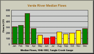

January through April is the primary season for trips on this section of the Verde River, where the water is free-flowing, and March historically has been the best month. A second season MAY exist from August through December, depending upon seasonal monsoons. Like all Arizona rivers, the Verde may not have a navigable season at all in drought years. Typically, the river can be boated any month of the year, though flows may be very low, at which time the bone zone may be very hard on boats and paddlers.

There are no significant hazards on this section of the Verde River other than cold water temperatures. Rapids are Class I to II, and are infrequently spaced along this flatwater section. Being prepared for high elevation and springtime Arizona paddling conditions avoids most problems. Because the best flow conditions occur during colder months wearing wetsuits, drysuits or water-repelling garments is advised for prevention of hypothermia. Be sure to carry extra clothing, in dry bags, for the eventuality of getting wet while paddling.

US Highway 89 bridge near Paulden at 0.0 miles; A rough USFS road off US Highway 89 at about 46.0 miles. There may be other access points for this run.

There are no commercial campgrounds located along this reach of the Verde River, which flows through Prescott National Forest. Primitive campsites can be found along the river. This is a "Leave No Trace" area (as everywhere you paddle should be), so be sure to leave the area cleaner than you found it.

There are no known liveries or outfitters operating along this section of the Verde River. Plan on setting up and running your own shuttles. Because of less-than-ideal conditions on the take-out road, allow adequate time for running shuttles. The one-way time can be 2 hours, or more, depending upon current road conditions.

"Verde" is Spanish for "green", and this is definitely a fitting name. All along the river is a verdant forest and beautiful tree-lined riverbanks in the oasis of central Arizona that is surrounded by desert. The general area of this reach is in Prescott National Forest near the gorgeous, snowcapped Red Rocks mountains of Sedona. About the only real drawback is the short season, as typical of most Arizona streams, usually flowing best from January through April, and possibly again in August through December, depending upon seasonal monsoon rains. This section of the river flows as a Class I to II stream without major hazards to navigation, and can be enjoyed by almost anybody in canoes, kayaks or rafts, but the water is cold so take care to avoid unplanned swims. Prime conditions usually occur during colder months, so appropriate apparrel is essential for preventing hypothermia. River-related services are non-existent, so bring everything you need and run your own shuttles. Excellent natural, primitive campsites are available along the river, but leave no trace of your having been there other than footprints. Beware of rattlesnakes if you choose to explore the surrounding rocky area. Bring your camera, because there is plenty to see and photograph on the river, as well as nearby.


