The Verde River forms at Sullivan Lake, where Big Chino Wash and Williamson Valley Wash merge south of Paulden in the Big Chino Valley of Yavapai County, then flows south by southeast about 170 miles to its Salt River confluence just northeast of Scottsdale and Phoenix. Along the way, it passes through parts of three national forests (Prescott, Cococino and Tonto), the cities of Cottonwood, Clarkdale and Camp Verde, and lands belonging to various tribes of the Apache Nation, private landowners and the State of Arizona. It is a perennial stream in a state known for its "dry" rivers, but it is not always boatable, and may have navigable flows in some reaches when others are too low to paddle. Its waters come from snowmelt in the mountains around the three forests, as well as seasonal monsoons. Surrounding lands are vastly disparate in nature, ranging from densely-forested upland plateaus to canyons to desert lowlands, each with its own diverse plantlife, animals, birds and fish. Beginning about 70 miles below the headwaters is a reach of 40.5 miles that is designated as "Wild and Scenic" by the US Congress, where the river and surrounding lands are perpetually protected against development and overuse.
Starting at Beasley Flat the river becomes part of the "National Wild and Scenic Rivers" program, and for good reason - it is wild and scenic out the wazoo! It also becomes more technically difficult as the river enters the deeper canyons with larger rapids and steeper drops. This reach of about 18 miles is rated Class II to IV, but Verde Falls, about 6.5 miles south of Beasley Flat, is a solid Class IV waterfall drop that has Class V consequences, especially at higher flows. The Falls is protected by a pre-fall rapid of sufficient difficulty. Both should be carefully scouted before running, and portaged if there is any doubt about safely running them. At low water levels the river is almost as challenging, especially for the survival of boats - many flatwater canoes have attempted this section and ended up abandoned in irreparable condition as a result of some sort of confrontation with boulders in the streambed. Paddlers should have at least strong intermediate level whitewater skills and be paddling kayaks, rafts or whitewater canoes with flotation on this reach. Of course, PFD's should ALWAYS be worn, but that becomes even more necessary here than on the flatter sections above, and those below Horseshoe Reservoir. This reach ends at Childs, about 6.5 miles above the East Verde River confluence. If you and your equipment are up to the task, and flows are cooperative, then this reach of the Verde River will provide an E-ticket ride in an area of very special natural beauty.

Yavapai County of central Arizona. Prescott sits to the northwest, and Flagstaff to the north. Metropolitan Phoenix is to the southwest. Parts of Cococina, Prescott and Tonto National Forests are home to this reach of the Verde River.

Flagstaff 56 miles; Phoenix 102 miles; Tucson 219 miles; Albuquerque miles; Salt Lake City miles; Denver miles; Oklahoma City miles; Dallas miles; Austin miles; San Antonio miles; Houston miles; Little Rock miles; Kansas City miles (all distances are approximate and depend upon starting point, destination point on the river and route taken.)

The Verde River flows clean, clear and cold from its headwaters to the Salt River on the outskirts of Scottsdale, Tempe and Phoenix. Flow is dependent upon winter snowmelt in Prescott National Forest for normal season paddling, and may be augmented by monsoonal rainfall in July through September for late summer through early fall paddle trips. Typically, you would prefer a flow of at least 400 cfs, but that is unusual other than in March. The river can be boatable at lower flows, but may require occasional walking and carrying or dragging through shallow areas. At flows above about 3,000 cfs, which are VERY rare, trees and brush lining the riverbanks become serious hazards to navigation. See table below for average monthly flows:
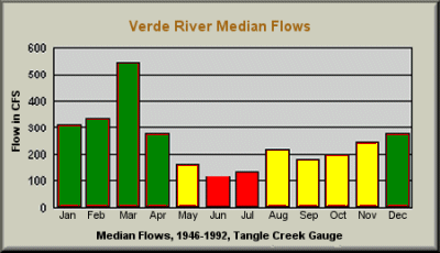

January through April is the primary season for trips on this section of the Verde River, where the water is free-flowing, and March historically has been the best month. A second season MAY exist from August through December, depending upon seasonal monsoons. Like all Arizona rivers, the Verde may not have a navigable season at all in drought years. Typically, the river can be boated any month of the year, though flows may be very low, at which time the bone zone may be very hard on boats and paddlers.

Permits are not required for private parties paddling this reach of the Verde River. Private parties are defined as those where no fees are charged for leading trips, or more specifically, trips where shared expenses represent the only transfer of money between group members. Commercial trips are required to obtain a permit from the offices of any of the three national parks through which this reach flows, and are very limited in number. For those planning to paddle below Childs, there are some special limitations to be observed. Upon entering the "Wild" portion of the "Wild and Scenic River" area private groups are limited to 15 persons maximum, and no more than 15 head of livestock may be a part of any group. Maximum consecutive days in this wilderness area is limited to 14 days.

Most of the rapids and drops on this reach of the Verde River are rated Class II to III, but there are several Class IV's. This reach should not be attempted by any paddler with less than strong intermediate level whitewater skills. Swiftwater rescue and First Aid training would be great assets. Cold water temperatures make water-repelling garments necessary, and wetsuits or drysuits would be ideal to protect against hypothermia, especially if running the river any time other than perhaps August through October. Hazards of significance include: Pre-fall Rapid (III to IV), at about 2.4 miles, is a boulder garden drop of great technical difficluty that can be lined on river left, or sometimes run after careful scouting - avoid unplanned runs that carry you through the Falls; Verde Falls, located at about 2.6 miles, is a serious Class IV with Class V consequences. Boats can usually be lined along the far left bank, though the Falls can be run by highly experienced paddlers in properly outfitted canoes and kayaks at higher flows. Running this drop at low water is NOT recommended!; Rock garden rapid (III), at about 4.5 miles, is difficult in low water conditions; Rock garden rapid (III), at about 5.5 miles, features sharp drops; Bull Run Rapid (II to III) at about 7.1 miles, is a 2 foot drop in low water conditions; Turkey Gobbler Rapid (II to III), at about 7.6 miles, features a strong current into a boulder on river right, with a nasty hole in high flow conditons. Scout before running; Bushman Rapid (II to III), at about 9.4 miles, is characterized by tricky lateral drops and holes, especially at lower flows; Black Hole Rapid (II to III), at about 10.4 miles, is a sharp drop onto rocks where pinning is easy at low flows; White Flush Rapid (II to III), at about 11.2 miles, is a boat-beating boulder banger; strainers at about 12.8 miles, are potentially VERY dangerous, and should be scouted before running; Boulder garden rapid, at about 13.3 miles, can be very hard on boats. Rapids on this reach have caused the death of many canoes and occasional rafts, so depending upon flow conditions and paddler skills, portages may be necessary to safely arrive at your downriver destination. This reach of the river has the potential for serious injuries or fatalities, so careful planning and adequate whitewater skills are necessary before attempting this run.

Beasley Flat River Access Point (RAP), on FR 334 (CR 328) about 3 miles off FR 574 (CR 163), at 0.0 miles; Brown Springs Ranch RAP, off FR 574, at about 9.0 miles (easy to miss from the river!); Childs RAP, off FR 502 about 6.2 miles from FR 708, at about 18.0 miles. There are no other access points for this reach of the Verde River.

There are no commercial campgrounds located along this reach of the Verde River. However, abundant natural, primitive campsites can be found all along the river. This is designated as a "Leave no trace" area, so be sure to take only photos and leave only footprints. Golfers may take along a rake to groom the areas where they walk so that the area is undisturbed for those who follow. This wilderness area has a limit of 14 consecutive days that you may remain here for any purpose.

There are no known liveries or outfitters operating along this section of the Verde River. Plan on setting up and running your own shuttles.

This is not classic hairboating, but technical difficulty on this reach of the Verde River demands attention and skills to avoid problems. The area is very remote, and the river flows through a deeper canyon. You may as well leave your cellular phone in the car, because it will be useless here. Scenery all around the river is just spectacular, with an abundance of animals, fish and birds, as well as native flora adorning the canyon walls and the uplands above the rim. You might see bald eagles, peregrine falcons, grey and black hawks, ospreys, Great Blue and green-backed herons, great and snowy egrets, white-faced ibis, and many varieties of songbirds, all of which are commonly found here. Amphibian and landlubber animals are plentiful, and rattlesnakes seem to love this place, so be careful where you step and place your hands. Obviously, not having a camera along would be a major loss, but make sure it is safely and securely protected against bumps and submersion. Water temperatures are cold most of the year, so wearing wetsuits or drysuits is recommended. Be sure to scout all rapids and drops before running them.


