The Verde River forms at Sullivan Lake, where Big Chino Wash and Williamson Valley Wash merge south of Paulden in the Big Chino Valley of Yavapai County, then flows south by southeast about 170 miles to its Salt River confluence just northeast of Scottsdale and Phoenix. Along the way, it passes through parts of three national forests (Prescott, Cococino and Tonto), the cities of Cottonwood, Clarkdale and Camp Verde, and lands belonging to various tribes of the Apache Nation, private landowners and the State of Arizona. It is a perennial stream in a state known for its "dry" rivers, but it is not always boatable, and may have navigable flows in some reaches when others are too low to paddle. Its waters come from snowmelt in the mountains around the three forests, as well as seasonal monsoons. Surrounding lands are vastly disparate in nature, ranging from densely-forested upland plateaus to canyons to desert lowlands, each with its own diverse plantlife, animals, birds and fish. Beginning about 70 miles below the headwaters is a reach of 40.5 miles that is designated as "Wild and Scenic" by the US Congress, where the river and surrounding lands are perpetually protected against development and overuse.
While not quite as challenging as the Beasley Flat to Childs reach above, this section, between Childs and Horseshoe Reservoir is about 42.5 miles of Class I to III whitewater rapids and drops that is fun and potentially dangerous, especially for inexperienced boaters. This is the last of the free-flowing part of the Verde River. The run starts just above the top of the Mazatzal Wilderness Area, where maximum group size is limited to 15 persons and no more than 15 head of livestock. Maximum consecutive days you may remain in this area is 14 days. There are 5 access points from Childs to Horseshoe Reservoir, but most require high-clearance vehicles. 4-wheel drive and/or mud chains may be necessary if the road is muddy. Travel time from Camp Verde is about 2 hours, and may be longer depending upon road conditions. The drive to the put-in is almost as exciting as the downriver run. The river continues its journey through the scenic portion of the designated "Wild and Scenic" reach, then passes through the wild portion on its way to the lake. It has much of the same topographical features as the Beasley to Childs reach, and shares the rapture of incredible flora and fauna found all along the Verde River corridor. The East Verde River confluence is on river left about 6.5 miles below Childs. Like the reach above, this one is best left to experienced whitewater boaters with at least strong intermediate level skills in properly outfitted canoes and kayaks. The often narrow channel makes for difficult rafting, and normal low flows add to the woes of big inflatable craft on this reach.

Cococino and Tonto National Forests of Yavapai County. Phoenix sits to the southwest, Flagstaff to the north and Prescott to the northwest. The small towns of Pine and Strawberry are to the east very near the start of this reach.

Flagstaff 72 miles; Phoenix 117 miles; Tucson 228 miles; Albuquerque miles; Salt Lake City miles; Denver miles; Oklahoma City miles; Dallas miles; Austin miles; San Antonio miles; Houston miles; Little Rock miles; Kansas City miles (all distances are approximate and depend upon starting point, destination point on the river and route taken.)

The Verde River flows clean, clear and cold from its headwaters to the Salt River on the outskirts of Scottsdale, Tempe and Phoenix. Flow is dependent upon winter snowmelt in Prescott National Forest for normal season paddling, and may be augmented by monsoonal rainfall in July through September for late summer through early fall paddle trips. Typically, you would prefer a flow of at least 400 cfs, but that is unusual other than in March. The river can be boatable at lower flows, but may require occasional walking and carrying or dragging through shallow areas. At flows above about 3,000 cfs, which are VERY rare, trees and brush lining the riverbanks become serious hazards to navigation. See table below for average monthly flows:
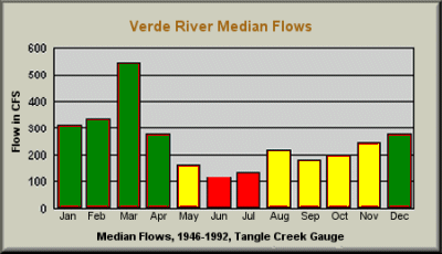

January through April is the primary season for trips on this section of the Verde River, where the water is free-flowing, and March historically has been the best month. A second season MAY exist from August through December, depending upon seasonal monsoons. Like all Arizona rivers, the Verde may not have a navigable season at all in drought years. Typically, the river can be boated any month of the year, though flows may be very low, at which time the bone zone may be very hard on boats and paddlers.

Permits are not required for private parties paddling this reach of the Verde River. Private parties are defined as those where no fees are charged for leading trips, or more specifically, trips where shared expenses represent the only transfer of money between group members. Commercial trips are required to obtain a permit from the offices of any of the three national parks through which this reach flows, and are very limited in number. Private groups are limited to 15 persons maximum, and no more than 15 head of livestock may be a part of any group. Maximum consecutive days in this wilderness area is limited to 14 days.

Rapids and drops on this reach of the Verde River are rated Class I to III, and have caused the death of many canoes and occasional rafts, so depending upon flow conditions and paddler skills, portages may be necessary to safely arrive at your downriver destination. This reach should not be attempted by any paddler with less than strong intermediate level whitewater skills. Swiftwater rescue and First Aid training would be great assets. Cold water temperatures make water-repelling garments necessary, and wetsuits or drysuits would be ideal to protect against hypothermia, especially if running the river any time other than perhaps August through October.
Hazards of particular note are: Child's Play Rapid (I to II) just below the put-in. Trees and waves make this a little tricky, so scout before running it; Baby Snaggleptooth Rapid (I to II), at about 1.0 miles, features a boulder in the center of the river at low flows, which means most of the time; a dogleg at about 3.7 miles is tricky as flows increase; strainer at about 4.0 miles, just below where the river forks briefly; boulders in river center at about 4.7 miles; strainers on river left in low water conditions at about 9.7 miles; Red Wall Rapid, at about 10.2 miles, features a current that carries boats into a bluff and trees on river right; strainer on river right at about 13.3 miles; Mell of a Hess Rapid (II to III), at about 22.3 miles, has trees blocking the channel (scouting is recommended); Red Creek Rapid (II to III), at about 23.3 miles, is a boulder garden that increases in difficulty at lower flows; Wet As Rapid (I to II), starting about at 23.6 miles, is a 3-drop rapid over about 0.1 miles; Rapid in the left fork just below Sheep Bridge RAP at about 32.7 miles should be scouted. There are no other significant hazards on this reach of the Verde River.

Childs River Access Point (RAP) on FR 502 about 6.2 miles from FR 708 at 0.0 miles; Houston Creek RAP (very rough 4WD road) at about 8.1 miles; Red Creek RAP (rough 4WD road) at about 22.7 miles; Sheep Bridge RAP (4WD, when muddy) on FR 269, about 42.0 miles from the Bloody Basin exit off IH 17, at about 32.7 miles; Ocotillo Boat Ramp on Horseshoe Reservoir at about 42.5 miles miles.

There are no commercial campgrounds located along this reach of the Verde River. However, abundant natural, primitive campsites can be found all along the river. This is designated as a "Leave no trace" area, so be sure to take only photos and leave only footprints. Golfers may take along a rake to groom the areas where they walk so that the area is undisturbed for those who follow. This wilderness area has a limit of 14 consecutive days that you may remain here for any purpose.

There are no known liveries or outfitters operating along this section of the Verde River. Plan on setting up and running your own shuttles.

While not quite as technically challenging as the reach above, the run between Childs and Horseshoe Reservoir still offers plenty of excitement on about 42.5 miles of Class I to III whitewater. The trick is to find the river when it has a navigable flow. In low-water conditions it is very bony and prone to severely damage boats with possible injury to paddlers. The area is quite remote, so having First Aid training and a major First Aid kit in your possession would be a great idea. Swiftwater rescue training would also be a valuable asset, along with the requisite rescue gear - all that training is almost worthless if you left your gear bag in the car or at home. Do not attempt this reach of the river unless you have at least strong intermediate level whitewater skills and are confident of your ability to safely run a wilderness whitewater river in your craft of choice. This would not be a good place to try out a new boat with which you are not familiar! Scenery is awesome and wildlife is all around, so bring the camera, but carry it protected from bumps and immersion. For best paddling, the colder months of January through April offer the most likely decent flows, though the river is runnable almost anytime after a significant local rain event. The downside to that is that the river is also prone to flash flooding when rains are heavy in its drainage basin, so keep an eye on the forecasts for the river and areas around it, and be prepared for whatever may ensue. Summer days will be very hot, but Arizonans like to say that it is a "dry heat", whatever that means! The Verde River is a gem among Arizona rivers in that it usually has flowing water, though not always at navigable levels. Coming mainly from snowmelt near its headwaters, the river usually flows cold, so be prepared with the proper apparrel and extra clothing in case you get wet. This is no place for hypothermia.


